Charles E. Corry, Eugene Herrin, Fred W. McDowell, and Kenneth A. Phillips
© Geological Society of America - 1990
| Home Page | Contents | Index | Comments? |
I send you a suddenly rearing horse and the scent of lion, with sunsets over ridges as old as life.
Few areas offer the geologic diversity found in the Solitario Quadrangle. The centerpiece is a structural dome formed by emplacement of a large (~100 cubic km) laccolith in late Eocene. Erosion of this 13-km-diameter dome has exposed a stratigraphic sequence that records the geologic history of the area since Cambrian. Paleozoic Ouachita facies, Cretaceous carbonates, and Tertiary Trans-Pecos volcanics are all well exposed in the quadrangle. The effects of three orogenies can be found in the rock record: the Llanorian in Silurian; the Ouachita in Pennsylvanian-Permian; and the Laramide in early Tertiary.
Extension fabrics in Cretaceous carbonates, formed during the growth of the laccolith, dominate the roof deformation. The remnant of a collapsed crestal graben block formed during the doming is found in the center of the dome. The dome was eroded to its present level by the end of the Eocene. Younger Tertiary volcaniclastic units onlapped partially over the eroded rim of the dome and protected it from further erosion. Intrusive and extrusive volcanic activity, both from within the dome and surrounding areas, provides a diverse suite of felsic and mafic igneous rocks. Metamorphism and hydrothermal alteration of many of the sedimentary and igneous rocks add to the complexity of the petrologic problems found within the quadrangle.
Pleistocene and Quaternary erosion have partially resurrected the Eocene topography and exposed the imposing feature seen today.
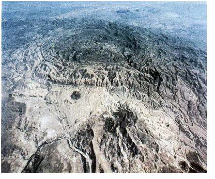
The Solitario displays geologic features that span virtually the entire regional history of Trans-Pecos Texas since Cambrian time. The visible structure (shown above) is the eroded remnant of the roof of a radially symmetric late Eocene (38 Ma) laccolith. Erosion of the laccolith roof has exposed a remarkably complete stratigraphic section. The rock record begins with Upper Cambrian Dagger Flat Sandstone. Deposition of Upper Cambrian sand and shale in a shallow sea gave way during Ordovician to deposition of black shales interbedded with some sand and black chert, reflecting more restricted circulation. About 1 km of sediments, from the craton to the north and northwest, accumulated in the Ouachita Trough during Late Cambrian and Ordovician time. The area was elevated and slightly tilted, but not significantly deformed, by the Llanorian Orogeny during Silurian time. Silurian rocks are missing, and the Lower Devonian-Mississippian Caballos Novaculite rests unconformably on the Upper Ordovician Maravillas Formation. More than 1.4 km of flysch, from a source to the southeast, forms the Mississippian-Pennsylvanian Tesnus Formation. No Paleozoic rock younger than Early Pennsylvanian (Morrowan Series) have been found. The measured thickness of Paleozoic rocks in the Solitario is approximately 2.6 km and represents a time span of 240 m.y. with a single break of ~30 m.y. during Silurian, one of the longest depositional records known.
The Paleozoic rocks found in the Solitario are allochthonous and were intensely deformed during the Ouachita Orogeny. The orogeny affected the Solitario area from Middle Pennsylvanian (Desmoinesian) until Early Permian (middle Wolfcampian). Transport of the allochton during the Ouachita Orogeny was at least tens of kilometers from the southeast. Deformation was primarily by folding, with the development of nappes, S-folds, boudinage structures, and local and regional thrust faults evident in the exposed Paleozoic rocks.
After the Ouachita Orogeny, the Solitario area remained positive from Early Permian (middle Wolfcampian) on the structural block known as the Tascotal Uplift that formed the southern margin of the Permian sea. Throughout early Mesozoic, the area remained elevated on the West Texas-Coahuila Platform, and was extensively eroded as part of the Wichita paleoplain. In Early Cretaceous (late Aptian), the area was covered by a shallow sea, and 1.2 km of carbonates were deposited. These rocks are now magnificently exposed in cross section in the shutups that cut the rim of the Solitario dome. The Cretaceous rocks are correlative with carbonate units found to the east and south in the Gulf Coast area.
At the end of the Cretaceous (Gulfian), the area was elevated once again as the Laramide Orogeny migrated eastward. Regionally, the Solitario lies on a large structural block that is defined by gravity data as a remnant of the Tascotal Uplift. The block appears to have responded to Laramide compression by uplift and rigid-body rotation without undergoing extensive internal deformation. Deformation associated with the Laramide Orogeny had no discernible effect on the later emplacement of the Solitario laccolith. Within the mapped area, Laramide compression is, at most, presently evident only as sparse stylolites in the Cretaceous rim rocks. Mid-Eocene basal conglomerate of the Devil's Graveyard Formation, shed from Laramide folds to the west, is found in Fresno Canyon, and is the only Tertiary rock that predates the formation of the Solitario dome.
The oldest reliably dated igneous rock in the Solitario is a 37.5 ±0.8 Ma rhyolite sill. The sill intruded the base of the Cretaceous section immediately prior to the formation of the Solitario dome. The dome was formed by intrusion of ~100 km 3 of silicic magma that formed the present granite laccolith shortly after emplacement of the rim sill. The structural relief of the dome is 1.6 km, and the roof underwent 400 m of radial extension from the center. A crestal graben formed during doming, and the graben block collapsed less than 1 m.y. after formation of the dome, foundering and rotating down to the south after the roof was deeply eroded. The foundering of the crestal graben block was probably contemporaneous with the emplacement of a granite intrusion on the eastern side of the collapsed block and formation of a small caldera south of the crestal graben block.
The series of intrusive and extrusive volcanic rocks found within the dome includes 14 mappable rock types, with a wide range of compositions. The Solitario igneous suite was emplaced over a total time span of 11 m.y.; silicic igneous activity was probably limited to the first 3 m.y. of this time. Younger, more mafic rocks have vents within the Solitario dome, and are thus included within the suite, but appear to be genetically and temporally related to the Bofecillos volcanic center immediately west of the dome.
The oldest units of the central basin-filling Needle Peak Tuff were deposited in late Eocene within 1 m.y. after the dome was formed. The roof of the dome was therefore eroded to virtually its present level by the end of the Eocene. The emplacement of the Needle Peak Tuff is associated, at least in part, with the collapse of a small caldera in the south part of the central basin. Volcaniclastic rocks accumulated in surrounding areas during the Oligocene and early Miocene, particularly those erupted from the Bofecillos volcanic center to the west. Early Oligocene Chisos Formation pinches out against the western flank of the dome. These volcanic units eventually lapped high onto the eroded rim of the dome, but did not spill over into the central basin.
From early Miocene until the Quaternary, the area was an elevated plain, with the streams at or near their base level. There is no evidence in the map area for significant erosion or deposition from early Miocene until the Pleistocene, when the Rio Grande began actively downcutting its bed to the south. The base level of all local streams was lowered as a result. The map area is presently being rapidly eroded, and the late Eocene topography has been partially resurrected.
As the exposures in the Solitario cover most of the rock record in Texas since the Cambrian, it is natural that areas of uncertainties and differences remain. Thus, the following discussions and replies may also be of interest:
Geological Society of America Bulletin, 1994, v. 106, no. 4, p. 560-569, discussion and reply (WHOI contribution 8455)
A Laramide age push-up block: the structures and formation of the Terlingua-Solitario structural block, Big Bend region, Texas,” by R. J. Erdlac in Geol. Soc. Am. Bull., v. 102, no. 8, p. 1065-1076, discussion and reply, v. 106, no. 4, p. 553-559, 1994 (WHOI contribution 8456).
Henry, C.D. and W. R. Muehlberger, Geology of the Solitario dome, Trans-Pecos Texas: Paleozoic, Mesozoic, and Cenozoic sedimentation, tectonism and magmatism, Bureau of Economic Geology, RIO 240, 182 p., 1996.
In working and reviewing the geology of the Solitario the “dream” of John McPhee in his book Basin and Range (p. 82-83) always comes to mind:
“I once dreamed about a great fire that broke out at night at Nasser Aftab's House of Carpets. In Aftab's showroom under the queen-post trusses were layer upon layer and pile after pile of shags and broadlooms, hooks and throws, para-Persians and polyesters. The intense and shriveling heat consumed or melted most of what was there. The roof gave way. It was a night of cyclonic winds, stabs of unseasonal lightning. Flaming debris fell on the carpets. Layers of ash descended, alighted, swirled in the wind, and drifted. Molten polyester hardened on the cellar stairs. Almost simultaneously there occurred a major accident in the ice-cream factory next door. As yet no people had arrived. Dead of night. Distant city. And before long the west wall of the House of Carpets fell in under the pressure and weight of a broad, braided ooze of six admixing flavors, which slowly entered Nasser Aftab's showroom and folded and double-folded and covered what was left of his carpets, moving them, as well, some distance across the room. Snow began to fall. It turned to sleet, and soon to freezing rain. In heavy winds under clearing skies, the temperature fell to six below zero. Celsius. Representatives of two warring insurance companies showed up just in front of the fire engines. The insurance companies needed to know precisely what had happened, and in what order, and to what extent it was Aftab's fault. If not a hundred percent, then to what extent was it the ice-cream factory's fault? And how much fault must be — regrettably — assigned to God? The problem was obviously too tough for the Chicken Valley Police Department, or, for that matter, for any ordinary detective. It was a problem, naturally, for a field geologist. One shuffled in eventually. Scratched-up boots. A puzzled look. He picked up bits of wall and ceiling, looked under the carpets, tasted the ice cream. He felt the risers of the cellar stairs. Looking up, he told Hartford everything it wanted to know. For him this was so simple it was a five-minute job.”
And after working in the Solitario one does tend to think of oneself as somewhat of a field geologist but still be left with many more questions than answers.
| Home Page | Contents | Index | Comments? |