James W. Perry, Univ. New Hampshire, Durham, NH, Charles E. Corry, Golden, Colorado, Theodore Madden, MIT, Cambridge, Massachusetts
| Home Page | Contents | Index | Comments? |
| Next — Advancing electrical methods of geophysics |
Delineating and monitoring leakage from aging or ruptured underground storage tanks is both a common and expensive problem. Typically the site must be extensively drilled and numerous water samples taken and analyzed in order to delineate the contaminant plume. Remediation efforts often require that ground water sampling be continued frequently over several years.
In contrast, discrete zones of hydrocarbon contamination around leaking storage tanks have been successfully mapped using spontaneous polarization (SP) methods at two separate locations in New Hampshire. Contaminated zones are distinct from their surrounding environment in SP surveys, and exhibit a negative potential whose magnitude is much greater than an order of magnitude above background levels despite severe cultural interference. One hydrocarbon plume associated with a leaking storage tank was located underneath asphalt paving behind a shopping mall in Stratham, NH. Three hydrocarbon plumes associated with such tanks located on Pease Air Force Base in Portsmouth, NH were successfully mapped using SP. In addition, remediation efforts at the former fire department training site at Pease AFB were well defined by the SP survey.
For comparison, a conventional dipole-dipole resistivity survey was run across a well defined, by both drilling and SP, contaminant plume at Pease AFB. No anomaly was evident in the resistivity data.
The results of this study indicate that SP is a viable, rapid, and inexpensive method for mapping hydrocarbon contaminant plumes even in areas of severe cultural interference. It is a quick, efficient, and inexpensive tool for investigating and managing common types of ground water pollution. SP can also be used for characterizing the subsurface extent of such plumes before any boring, drilling, or installation of monitoring wells over a much broader area than can typically be done economically by other methods. SP can also be used to monitor cleanup and remediation efforts as the SP anomalies disappear when the contaminants are removed.
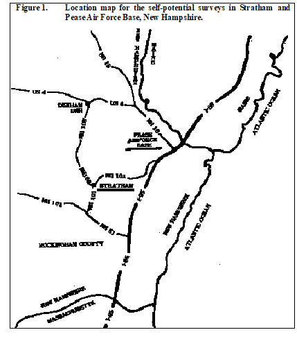
Five sites located in two separate areas in southeastern New Hampshire (Figure 1, Click
here
for PDF location map) were investigated by Perry (1996). The first area is located behind Kings Highway Plaza (Figure 3), a shopping mall, in the town of Stratham, NH, dating from the 1970's. A storage tank under the asphalt paving had been leaking Diesel fuel for an undetermined amount of time prior to its removal in 1987. Drilling had previously delineated the contaminant plume.
The remaining 4 sites are located on Pease Air Force Base (Figure 2, click here for full-size PDF figure) near Portsmouth, NH, in Rockingham County. The base is in the middle of a peninsula formed by the Pisqcataqua River, the Little Bay, and the Great Bay.
With the onset of World War II, an airport at the current base location was used by the U.S. Navy and the Air Force assumed control in 1951. Construction of the present base was completed in 1956. The mission was to maintain a combat ready force capable of long range bombardment operations.
Over time, various quantities of fuels, oils, lubricants solvents, and protective coatings were used to support the mission. Consequently, release of various contaminates occurred. Some examples of these were: disposal of wastes in landfills, spills of fuel oil, oils, solvents, leaks from underground tanks, residual products from fire training exercises, and disposal of flammable liquids at burn areas.
Pease AFB was closed as an active military base on March 31, 1991, although the Air National Guard remains. The Installation Restoration Program (IRP) of the Department of Defense was initiated at Pease in 1993.
One site at Pease is a former AFB Fire Department Training Area (Figure 2, click
here
for full-size PDF figure) that was active between 1961 and 1988. Currently ground water is being extracted from recovery wells at this site and treated to remove undissolved oil, JP4, and dissolved organic contaminants. Some contaminated soil has been removed and a pilot soil vapor extraction system is being installed to remove and treat contamination in subsurface soils and petroleum products floating on the ground water surface.
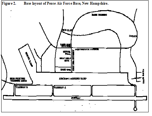
A second site at Pease AFB is the Base Exchange gas station operated from 1957 to 1991 as a commercial filling and automobile repair station. A total of eleven gasoline, fuel oil, and waste oil underground storage tanks were located on the site prior to removal around 1992. After the tanks were removed, about 1000 tons of contaminated soil was excavated and replaced with sand fill.
The third site is the Motor Pool operated from 1958 to 1991 as a gasoline and diesel fuel filling station for military vehicles. A total of five underground storage tanks were removed from the site between 1989 and 1991.
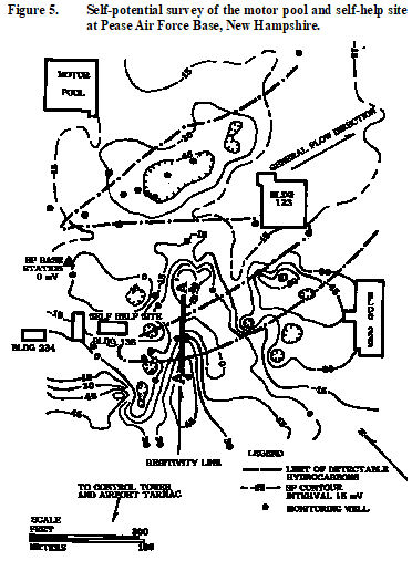
The fourth area at Pease AFB was the Self Help Site, which was a vehicle maintenance facility used for Air Force and personal vehicle maintenance. A 15,000 l tank on site, removed in 1989, had received discharge from an oil/water separator. The oil/water separator also received effluent from the Building 136 floor drains. Floating hydrocarbons are currently being collected from a free-phase product recovery well. Approximately 75 l of hydrocarbons have been recovered from the well as of January 1993.
New Hampshire lies within the Appalachian segment of the Appalachian province. The southeastern portion of New Hampshire consists primarily of a sequence of Precambrian to Devonian age folded and faulted metasedimentary and metavolcanic rocks. Regional mountain building episodes occurred during the Devonian Acadian orogeny. Various intrusive igneous rocks, largely of granitic composition, were emplaced during this orogeny. During the Triassic period, continental rifting began, resulting in bands of northeast-southwest normal faulting, roughly parallel to the present coast of New Hampshire. These faults and associated fractures served to localize emplacement of debase and gabbroic sills and dikes.
Diabase dikes at Pease AFB are more resistant to weathering than the host metasedimentary rocks and tend to form localized bedrock topographic highs that channel groundwater flow.
Surficial geology is primarily glacial deposits of Wisconsin age. The Wisconsin ice sheet reached its maximum extent by 22,000 years ago.As the continental ice sheet retreated, melting released large quantities of debris that accumulated as a surficial blanket consisting of lodgement and ablation tills, stratified drift, and outwash. Locally, thick accumulations of stratified drift, or deltas, were laid down in front of the ice margin. The stratigraphic sequence of the glacial deposits of coastal New England in the study area are, in ascending order; till, stratified drift including subaqueous outwash and marine clay and silt of the Presumpscot Formation; and outwash, including ice-contacts deltas and marine washover fans. Except for the till, all of the glacial units were deposited in a marine environment.
The methods used for making spontaneous polarization measurements are described in general in Corry (1985) and in detail in Corry et al. (1983). A fixed base station was used for all SP surveys. A copper sulfate saturated sponge was placed between the electrode and the pavement, when present, to improve electrode contact when making measurements on asphalt or cement paving. Electrode drift averaged ±5 mV and the repeatability of reoccupied stations was within ±5 mV even in areas of extreme cultural interference.
Cultural interference during SP surveys comes from a variety of sources such as power stations and power lines, pipelines and tanks with cathodic protection, culverts, grounded fences, drill hole casings, and other metallic objects in the ground (Corry, 1985). Natural noise during SP surveys can also come from telluric currents. Input filters in modern, hand-held, high-impedance digital voltmeters make it possible to operate in areas, such as on the asphalt paving of shopping malls, where interference was previously too extreme. That technological advance makes the current SP surveys possible.
Electrical resistivity measurements were taken only at the Self Help Site. A dipole-dipole electrode array was used in an attempt to detect a conductivity zone in the hydrocarbon plume as delineated by SP and drilling. Surveys were run perpendicular to the long axis of the contaminant plume.
All survey lines were extended well beyond the edges of the known plumes. In some cases, however, the SP data indicate the plumes now extend beyond previously known boundaries.
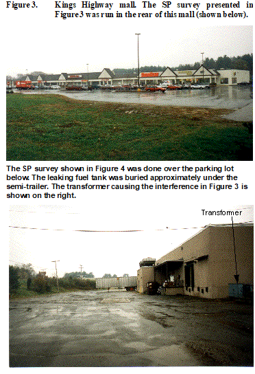 The first SP survey (Figure 3) was run behind a shopping mall in June, 1993. The building on the property is a 10,000 m
2
one-story mall set upon a concrete foundation and surrounded by an asphalt-paved parking lot. The building is heated by an oil-fired hot air heating system originally fueled from an 30,000 l underground storage tank. That tank was removed in 1987. There was visible evidence of oil in the ground water at the time of removal.
The first SP survey (Figure 3) was run behind a shopping mall in June, 1993. The building on the property is a 10,000 m
2
one-story mall set upon a concrete foundation and surrounded by an asphalt-paved parking lot. The building is heated by an oil-fired hot air heating system originally fueled from an 30,000 l underground storage tank. That tank was removed in 1987. There was visible evidence of oil in the ground water at the time of removal.
The presence of Parkman Brook to the east of the site results in local ground water flow towards the east-southeast.
SP survey lines were run in a grid pattern covering the estimated flow direction and strike of the plume both on and off the parking lot. Station spacing was 5 m and the line spacing was 10 m.
Results of the SP survey have been compared with the water quality data from a previous ground water investigation of the fuel oil release. A direct correlation exists between the concentration of the total petroleum hydrocarbon concentrations known from drill holes and the negative SP anomaly shown in Figure 4 (click here for full-size PDF figure).
Cultural interference is only evident as a small anomaly located at the upper northwest corner of the survey area (Figure 4,click here for full-size PDF figure) that coincides with an electrical transformer located behind the shopping plaza shown at bottom of Figure 3.
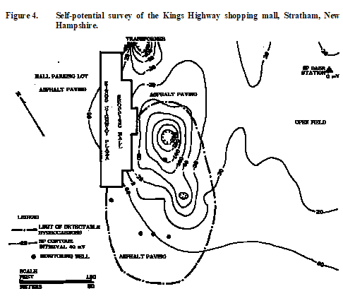
The SP survey has thus delineated the relative concentrations and the lateral extent of the release of No. 2 fuel oil despite severe cultural interference.
 The second, and subsequent SP surveys were conducted at Pease Air Force Base (Figure 2, click
here
for full-size PDF figure) near Portsmouth, NH. SP was used during June, 1993, in an attempt to detect and delineate waste oil fuel released from a 15,000 l underground storage tank at a former vehicle maintenance facility.
The second, and subsequent SP surveys were conducted at Pease Air Force Base (Figure 2, click
here
for full-size PDF figure) near Portsmouth, NH. SP was used during June, 1993, in an attempt to detect and delineate waste oil fuel released from a 15,000 l underground storage tank at a former vehicle maintenance facility.
Survey lines were run in a grid pattern with a station spacing of 6 m and a line spacing of 12 m. The data are marred by two spurious potential readings of –70 mV and –50 mV of undetermined origin.
The SP survey (Figure 5, click here for full-size PDF figure) at this site was overlain on the water quality data from a previous investigation of the waste fuel oil release. A coarse negative SP trough roughly tracks the position of the waste oil plume delineated by the drill hole data. The SP values become increasingly negative near the eastern most tip of the water quality contour map suggesting that the plume has migrated further down gradient since the water quality contour map was drawn. The small negative SP values at the head of the plume (near building 136) are probably indicative of the removal of hydrocarbons in this area by the adjacent pump and recovery well.
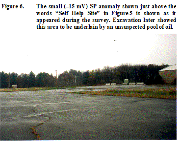 A small negative SP anomaly was also found just northeast of building 136 and the self help site (Figure 5, click
here
for full-size PDF figure). Several weeks after the SP survey was completed, Pease AFB started doing excavation work in that area. To their surprise, it was discovered that a significant quantity of oil had migrated into this area, strongly reinforcing the correlation of the SP anomalies with hydrocarbon accumulations.
A small negative SP anomaly was also found just northeast of building 136 and the self help site (Figure 5, click
here
for full-size PDF figure). Several weeks after the SP survey was completed, Pease AFB started doing excavation work in that area. To their surprise, it was discovered that a significant quantity of oil had migrated into this area, strongly reinforcing the correlation of the SP anomalies with hydrocarbon accumulations.
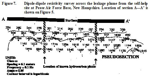
Resistivity data were also taken at this site using a dipole-dipole electrode configuration (Figure 7, click here for full-size PDF version of figure), with a 6.1-m a-spacing, during October, 1993 at this site. The survey was done in an unsuccessful attempt to see if a significant resistivity contrast could be found between the oil plume and the uncontaminated ground water. The resistivity data indicate that the apparent resistivity of the overburden is fairly homogeneous for the length of the survey line.
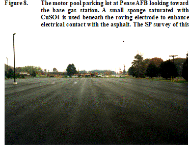 At this site, SP was used to detect and delineate a plume containing oil and gasoline. The motor pool parking lot and the base gas station (Figure 9, click
here
for full-size, PDF figure) are shown in Figure 8.
At this site, SP was used to detect and delineate a plume containing oil and gasoline. The motor pool parking lot and the base gas station (Figure 9, click
here
for full-size, PDF figure) are shown in Figure 8.
Survey lines were run in a grid pattern with a station spacing of 7.6 m and a line spacing of 30 m. The SP data were overlain on the water quality data from a previous investigation of the oil/gasoline plume. Again, a negative SP anomaly (Figure 5, click here for full-size PDF figure) exists immediately over the location of the plume determined from the drill hole data.
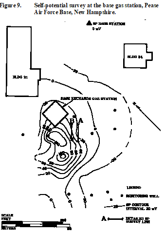 The third SP survey conducted at Pease AFB (Figure 2, click
here
for full-size PDF figure) was done at site 33 during the months of June-July, 1993. At the gas station an attempt was made to detect and characterize the SP anomaly associated with a plume containing gasoline.
The third SP survey conducted at Pease AFB (Figure 2, click
here
for full-size PDF figure) was done at site 33 during the months of June-July, 1993. At the gas station an attempt was made to detect and characterize the SP anomaly associated with a plume containing gasoline.
Survey lines were run in a grid pattern with a station spacing of 6 m and a line spacing of 12 m.
In the area over the plume resulting from the leaking tank at the gas station, the asphalt pavement has been removed, together with the native soils and overburden, in an attempt to remove all contaminated soil above the water table. The native soils were replaced with ~1000 tons of clean, medium-to-coarse grained sand.
The SP survey (Figure 9, click here for full-size PDF figure) was again overlain on the water quality data from a previous investigation of the gasoline release from the former service station. However, in this case, a positive SP anomaly now exists immediately over the location of the volatile organic compounds delineated by drill hole data. As mentioned above, since the water data were taken the contaminated soils were excavated and ~1000 tons of clean sand were put in. This positive anomaly reflects the Nernst potential difference between the native soils and the imported clean sand. This was demonstrated by running detailed SP surveys, with a 15-cm sampling interval, over the physical contact between the new, clean sands and the native soils. From north to south on line A (Figure 10, click here for full-size Line A) the SP signal rises sharply from –12 mV to +47 mV within 30 cm at the northern contact. To the south, as one leaves the clean sands and enters native soils, the potential drops from +27 mV to –7 mV across the contact within a distance of 20 cm. Similar results were obtained on second survey, line B (Figure 10, click here for full-size Line B) whose location is shown on Figure 9 (click here for full-size PDF figure), over the same replacement sands.
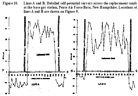
Natural self-potentials will develop at any contact between two materials of different electrochemical properties (Ishido and Mitzutani, 1981). Thus, the positive anomaly associated with the clean sand fill demonstrates the utility of using the SP method to monitor remediation efforts.
For the last survey, SP was used to map a plume containing JP4 and waste oils at Site 8 (Figure 11, click
here
for full-size PDF figure), the former fire department training area. The bulk of the SP survey was conducted during June-July, 1993.
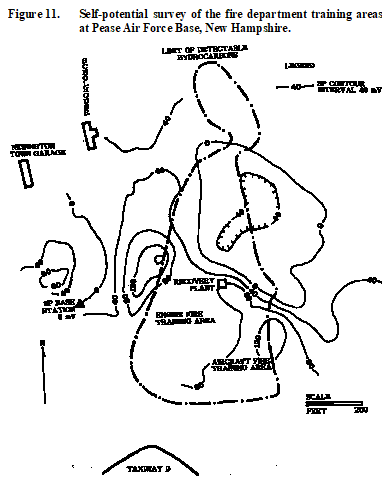
The majority of the fire training exercises were performed in a large circular pit area located at the southeastern portion of the site. Aircraft fires were simulated using 200 to 1000 gallons of JP-4 fuel. Training exercises were conducted about 2-4 times a month. The training procedure was to presaturate the pit with water, and then to pour waste oils and fuel on top a mock aircraft. The mixture and the aircraft were then ignited and allowed to burn for ~2 minutes before extinguishing the fire. Some time between 1974 and 1975 the pit was refurbished and an underground sprinkler system was installed to spray jet fuel into the pit area by an underground fuel line. Unburned fuels from the mock fire drills eventually discharged into a drainage ditch at the northern end of the site.
SP lines were sufficiently long to cross well beyond the edges of the plume and were later extended so that the length of the SP lines were about 2-3 times the average width of the plume to obtain background data. The station spacing was 7.6 meters and the line spacing was 15.2 m.
Again, the SP data (Figure 11, click here for full-size PDF figure) were overlain on the water quality data from a previous investigation of the JP4/waste fuel oil released at the former fire department training area. A negative SP anomaly occurs in the same general vicinity of the mapped location of free phase hydrocarbons, and volatile organic compounds. However, the SP contours are offset from the water quality plume contours and that may be due to several different factors.
Approximately three years elapsed between the sampling used as a basis for the water quality contour map and the time of the SP survey. The plume has thus had time to spread out and diffuse. Another possibility for the shift of SP data may be remediation efforts associated with the ground water treatment plant and four treatment recovery wells. These wells are being used to evaluate potential treatment technologies. In either case, it is clear SP surveys can be used as a low-cost method of obtaining time-dependent variations of contaminant plumes. Corry (1985), among others, has shown that SP surveys are repeatable from year-to-year so long as the same base station is used. Thus, the only variations expected are due to contaminant migration or remediation efforts.
The results of these SP surveys clearly demonstrate that the method is able to cheaply and effectively detect and delineate hydrocarbon plumes. Additionally, SP can be used to monitor time-dependent variations in contaminant migration and remediation effects.
Moreover, modern instrumentation makes it possible to make reliable SP surveys in areas of severe cultural interference.
We would like to thank Steve Flink, the Environmental Enforcement officer for Stratham, NH, as well as Art Ditto and Jay Grumbling from the Pease Air Force Development authority for giving us their time, resources and unlimited access to the sites. Without their cooperation, this research could not have taken place.
Corry, C. E., DeMoully, G. T., and Gerety, M. T., 1983, Field procedure manual for self-potential surveys (PDF, 3.7 MB), Zonge Engineering Research Organization, 3322 East Fort Lowell, Tucson, Arizona 85716, USA, telephone (520) 327-5501.
Corry, C.E., 1985, Spontaneous polarization associated with porphyry sulfide mineralization: Geophysics, 50 , 1020-1034.
Ishido, T. and Mizutani, H., 1981. Experimental and theoretical basis of electrokinetic phenomena in rock-water systems and its applications to geophysics: Geophysics, 86 , 1763-1775.
Perry, J. W., 1996, Applications of spontaneous polarization in the detection and delineation of hydrocarbon spills from underground storage tanks: M.S. thesis, Univ. of New Hampshire.
| Home Page | Contents | Index | Comments? |
| Next — Advancing electrical methods of geophysics |