| Home Page | Contents | Index | Comments? |
| Next — Shipwrecked and Marooned |
The following account was accepted in July, 1967, by GeoMarine Technology. Unfortunately, the magazine ceased publication before our story was printed. Dr. Herbert Windom was scientific leader for the climbs, which occurred in January, 1966. At the time he was a graduate student at Scripps Institution of Oceanography in San Diego, California. His dissertation research basically required him to climb as many high mountains as possible around the world and collect ice samples from them in order to derive sources for aeolian (wind) borne ocean sediments. Drs. Timothy J. G. Francis, William E. Farrell, and I were on our way from La Jolla to Panama to join an oceanographic expedition and volunteered to help him with his work in Mexico on our way down. I have slightly edited the text here to correct tense and obvious errors. Units are given in both metric and English measure.
Geochemical studies then underway at the University of California at San Diego required ice samples from high altitude snow fields at varying latitudes around the world. These samples were analyzed for mineral content and an isotope of lead, Pb
210
. These studies were used to help determine worldwide distributions of wind-borne materials that contribute to oceanic sediments.
In order to gather samples for these studies a team of four scientists from the Scripps Institution of Oceanography recently set out to climb Mexico's two highest peaks, Mt. Popocatépetl and Mt. Orizaba. All of the party had climbed in the western United States and two in the Swiss Alps; but it was the first time any of the group had ascended over 5,000 meters.
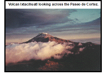
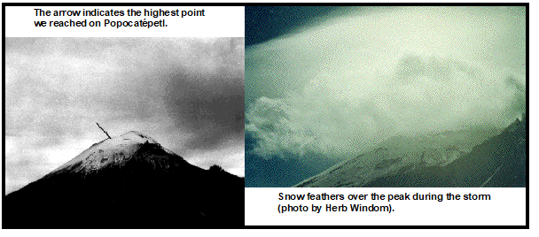
The volcano, Mt. Popocatépetl, lies forty-five miles southeast of Mexico City. At 5,452 m (17,887 feet) it is the fifth highest mountain in North America. Because of its proximity to Mexico City, and the easy access to its base, it is one of the most frequently climbed of the world's very high mountains (over 5,000 meters). Popocatépetl was first climbed in 1519 by Diego de Ordaz, one of Cortes' captains, who was looking for sulfur during the advance on Mexico City via the Paseo de Cortes. That also gives it the distinction of being the first very high mountain to be climbed by Europeans.
The ascent to the base of Popocatépetl is via a dirt road that leaves the main road from Mexico City just south of the town of Amecameca. At about 4,000 meters (13,000 feet) elevation, a large stone hut has been constructed by the Alpine Club of Mexico on the Paseo de Cortes, which lies between Popocatépetl and its twin, Ixtacihuatl. This hut is easily reached by car. Another small and exposed hut sits at about 4,300 meters (14,200 feet) on the north side of the cone, but cannot be reached by vehicle unless it is equipped with four-wheel drive.
We reached the hut early in the afternoon, having left Mexico City by car that morning. During the rest of the afternoon we made a leisurely ascent to the second hut, without taking any equipment, to learn the trail and condition ourselves to the altitude. We then returned to the hut for the night.
 We arose at 0300 the next morning to begin the climb. Herb had been sick all night from the altitude. None of us had slept well due to the cold and the altitude; but after standing around the fire awhile and having something to eat, we felt up to the climb. The food, extra clothing, and the equipment required for collecting the ice samples were distributed as equitably as possible. At about 0400 hours we left the first hut and began the ascent up the road toward the second hut. The road, as we knew, soon turned into a path of ankle-deep, loose volcanic ash. The addition of 7-kg (15-pound) packs and darkness making what the previous afternoon had been a leisurely stroll into a thoroughly miserable climb. The ash seemed twice as slippery, and we seemed to lose more than we gained at times. After much sweat (at –7°C [20°F]!), expletives, and stumbling through the ash in darkness, we finally arrived at the second hut, a mile further on and a thousand feet higher than the first one. As the sun did not rise until 0630 hours, we were forced to wait at this hut for 30 minutes for adequate light to continue, as this was as high as we were familiar with the route. Someone in Mexico thoughtfully kept this hut securely locked so we spent the ensuing 30 minutes huddled together like a small flock of sheep, unsuccessfully attempting to keep warm in its dubious lee.
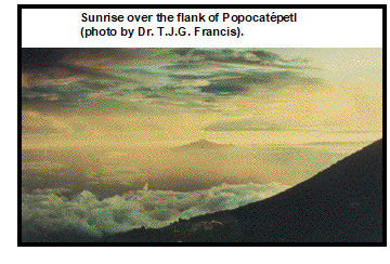
At sunrise we obtained some beautiful color photographs in partial repayment for those 30 cold minutes. Then, as it was now light, we started up a 30° rock slope directly behind the hut. We reached the top of the rocks at 0700 hours, elevation about 4,600 meters (15,000 feet).
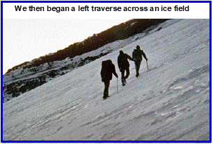
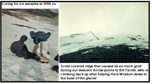
We then began a left traverse across an ice field. Herb's crampons were broken, and this necessitated cutting many steps in the ice even at the moderate angle at which we were climbing. We completed this traverse by 0800 hours and continued up a ridge of ice and rock. By 1000 hours we had reached an altitude of about 5,000 meters (16,500 feet) and found a suitable site for sampling the ice.
Up to now the winds had been very moderate at about 25 to 30 kph (15 to 20 mph) but increased continuously from then on. When we stopped to collect the samples my legs developed severe cramps; I was nearly immobilized for about half an hour. After food and rest I was prepared to go on by 1100 hours, when the coring for ice samples was completed. Our original plan was to collect the ice samples the first day and climb to the summit the next. But it looked so close from the ice sampling station that we decided to make the assault that day. Tim and I then continued up from there while Bill help Herb down to the base of the glacier with the ice samples and coring equipment. Bill left the equipment there for retrieval on our descent and started back up the glacier following our path. The wind had now increased to 50-65 kph (30-40 mph) but as yet was no serious handicap to our progress, although it was very chilling.
Tim and I continued up an ice fall with an average slope of 45° to 50°. We had been in the lee of a small ridge; but as we neared the top of it wind speeds increased to about 100 kph (60 mph) Despite this, we continued up by laying on the ice during the worst gusts, and climbing as fast as possible during the lulls. In this manner we managed to make it up to about 5,275 meters (17,300 feet), but wind speeds had increased to more than hurricane velocity in the gusts. It was only by clinging to the ice that we managed to keep from being blown away.
At this altitude we encountered a crevasse that forced us to traverse left and go down a very precipitous 15 meters (50 feet). In the next half hour we managed only to get down and across the crevasse and gain back 30 meters (100 feet). The majority of our time was spent pinned to the ice. In the next 15 minutes we were only to move up 6 meters (20 feet). Then we were pinned down for about 15 more minutes during which we were entirely unable to move. We could see from clouds that were being blown over the peak that the wind was much faster, probably at least 160 kph (100 mph), further up. That, coupled with the fact that we were finding it increasingly impossible to move, made us decide to give up the attempt.
We started back down. Bill met us at about 5,200 meters (17,000 feet), and we found a small lee and ate while we discussed the situation. At about 1430 hours we continued on down. Wind speed seemed to increase even more; and though we were partially in the lee of the mountain until we reached the base of the glacier, we occasionally experienced difficulty on the ice.
When we reached the bottom of the glacier we collected the equipment left there earlier. As we started along a scree-covered ridge our situation became even more precarious. It took us over an hour to traverse this ridge, which would have taken less than 15 minutes during a normal descent. Winds were so strong while on the ridge that, with our backs braced into the wind and leaning on our ice axes for support, we were picked up and thrown down the ridge for several meters before recovering. This happened to all of us at least half a dozen times during the traverse. Pebbles the size of peas were continually picked up by the wind and blown at us like machine-gun bullets.
The scree was so slippery in the wind that the volcanic ash we had cursed so in the morning, going up, seemed a real blessing to walk on when we finally got down to it. But the wind drove the ash into our eyes, ears, noses, mouths, hair, and boots until we were colored gray-black.
We arrived back at the lower hut as it began to snow.
Herb had reached the hut ahead of the worst of the storm but he had experienced some trouble on the same ridge we did. He managed, however, to get some excellent photographs of the storm roaring over the peak.
Since we had accomplished the main object of the expedition, gathering the ice samples, we made no further attempt to climb Popocatépetl. We could also see from the valley that the peak had acquired a good deal of new snow that would have made any climbing difficult.
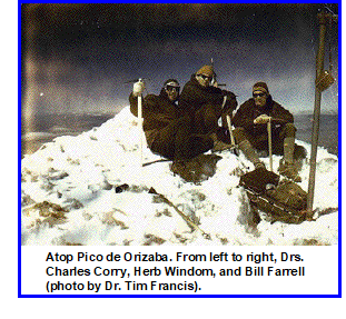
Two days later the entire party climbed to the peak of Mt. Orizaba which, at 5,700 meters (18,696 feet), is the third highest peak in North America. On our descent we collected ice samples from its glacier at about 5,500 meters. The ascent, from the overnight hut at 4,300 meters (14,000 feet) on Orizaba's flank, to the peak took us a little over 7 hours.
Tim, Bill, and I left Mexico two days after climbing Orizaba for Balboa, Panama, to join the oceanographic expedition Papagayo, where further adventures awaited us. Herb remained for five days to label and organize his samples and then returned to San Diego where he completed his doctorate the next year.
| Home Page | Contents | Index | Comments? |
| Next — Shipwrecked and Marooned |