| Home Page | Contents | Index | Comments? |
| Next — Horseback through Utah, Arizona, and Colorado |
| Back — Defeat on Popocatépetl |
As of early 2009 our adventures on Isla de la Guarda have taken on a veneer and life of their own. As a result the following account has been updated and additional details and photographs added with regard to our adventure.
I did so well with the terrestrial heat flow program at Scripps Institution of Oceanography that during 1966 Prof. Victor Vacquier gave me a project he had attempting to measure continental drift between the Baja Peninsula and the mainland using the same astrometric methods astronomers have for measuring the proper motion of stars.
Basically, to measure the proper motions of stars you use two fixed points of light for reference, i.e., stars that are effectively infinitely far away, and a third point that is moving, e.g., a nearby star, photograph them over time with a telescope and, if you know distances (usually measured by red shift for stars), you can easily calculate how far the third point moves.
Note that at the time continental drift was a rather radical concept proposed by Alfred Wegener in 1912 and virtually ignored afterward. The concept of seafloor spreading was brand new, having been proposed by Harry Hess in 1960, and only a few radicals, like Vic Vacquier's group at Scripps had accepted it. Vic had been given the stuffed albatross award in 1963 for displacing the Pacific Ocean by 1,120 km (700 miles) along the Mendocino Fracture Zone after completion of the PIoneer survey by Mason and Raff using Vic's magnetometers. So the idea that the Baja California Peninsula was floating away from North America was not mainstream science. But minor details and obstacles never slowed Vacquier down.
As originally proposed the idea was to set up a light station on Isla Tiburon and a telescope at Bahia de las Angeles. Never content to keep my mouth shut, after being given the project I told Vacquier the experiment needed to be redesigned, and moved so the light path was across the Canal de Ballenas between Isla Angel de la Guarda and the Baja Peninsula. Based on the available bathymetry I argued the main fracture zone, or spreading center, must lay beneath the Canal de Ballenas, and the light path would be considerably shortened. Remarkably, he agreed with me. As Vacquier put it in a salary review dated June 30, 1967, that I came across while reviewing my work in 2009 at the request of an archeologist hired by the Mexican government:
“...Corry reviewed the geological information with the help of Bob Fisher and convinced me that a much nearer island, namely Angel de la Guarda was just as good. This overcame morass of logistic and political difficulties and increased the precision of the measurement by a factor of four at least...”
It may be of interest to note that at the time I had no college degrees and was making a grand total of $677 per month, which was a fairly good salary at the time. For example, we owned a home at the corner of 7 th and Stratford, just one block up from the beach in Del Mar, California. I also drove a Triumph TR 3 sports car and had a tempestuous on again/off again marriage to a former TV comedian, race car driver, and skydiver on that salary.
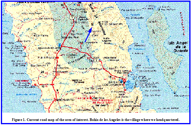
Shortening the light path is not to say the logistics were all that simplified. At the time, the Sailing Directions stated that Isla Angel de la Guarda was unexplored. The nearest village, Bahia de los Angeles, on the Baja Peninsula, was 20 to 30 nautical miles away by sea across the Canal de Ballenas.
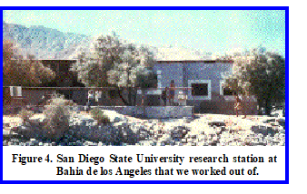
Vic was familiar with a group at San Diego State University who maintained a research station (Figure 4) and vehicle at Bahia de los Angeles. The
“station”
was the abandoned headquarters of a silver mine that had ceased operations in 1910. The vehicle was an International Travelall that had seen a better decade or two but was adapted for rough conditions.
After making arrangements with San Diego State, in late March of 1967 we flew to Bahia de los Angeles from Tiajuana on Baja Airlines with Capt. Munoz as pilot and steward, for a reconnaissance of what local support was available and what the terrain looked like.
Baja Airlines consisted primarily of a well-used Twin Beech aircraft that Capt. Munoz maintained along the way. It wasn't unusual for him to pull off the engine cowlings during a stop and do some maintenance or an engine tuneup.
Since we were planning on putting a telescope and light station on a peak near Punta Remedios on the Baja Peninsula north of Bahia de los Angeles we went as far north as possible in the Travelall to get a feel for access by land. We then hiked up a hill to get an overview of the terrain.
It quickly became obvious that any access to Punta Remedios was going to be by sea, which we had suspected. But I remember getting a flat tire on that trip in the midst of a bunch of hornets. Your hero then had to change the tire while the hornets flew around and landed on everything, including me, and Vic stood back and watched.
The abandoned mine headquarters (Figure 4) were quite adequate for our purposes and, after the scorpions were periodically swept out, we used it extensively during later operations.
None of the locals we talked to had ever been further than the beaches on the island, or knew anyone who had. Although after rain storms water can sometimes be found in a number of tinajas, no reliable source of water on Isla Angel de la Guarda was known then or now. Clearly we were definitely venturing into Terra Incognito.
Vacquier had a wry sense of humor and considerable experience with aircraft from his time at Sperry Rand. So while we were waiting to board Baja Airlines for our return trip from Bahia de los Angeles, Vic walked around the aircraft sniffing the leaking fluids and announcing his conclusions for the benefit of two adventurous widow ladies flying with us. On the flight Vic was sitting several seats in front of me with the widows between us. As we were coming in to land at Tiajuana Vic called back to me to ask if I'd heard the wheels lock down. I told him I hadn't but that we would find out shortly if they had. However, I don't think the widow ladies appreciated our august company or comments.
Having gotten the lay of the land and sea I began organizing the expedition. But then I got appendicitis. The operation set me back couple of weeks.
Since landings across an open beach would be required to access any of the possible sites, we bought an 11-m (36-foot) surplus landing craft, vehicle, personnel (LCVP) and named it the R/V Charley Bear. I was well acquainted with LCVPs courtesy of the Navy and Marine Corps, having taken my sensitivity training with Marine Corp infantry (1 st Marines).
Surplus LCVPs were common in San Diego in 1967 so it wasn't much of a problem to find a contractor to sell Scripps one and refurbish it for us. The only navigational instrument we installed was a magnetic compass but ocean journeys weren't contemplated. For a dinghy we acquired a Sabot, a small 2-m (7 foot) sail boat to which we added some oars. The contract specifications for the good ship R/V Charley Bear are dated May 15, 1967, my 29 th birthday. The R/V Charley Bear was delivered to the Scripps Marine Facility on Point Loma in early July as I recall. We did sea trials and had the compass professionally compensated in San Diego harbor after delivery. Meanwhile my marriage was off again.
We also acquired a surplus International 4-WD pickup and modified it with airplane tires and heavier shock absorbers for the work ahead. The University of California, and most universities, are eligible for government surplus, including vehicles. So what we would do is go to the surplus yard which, as I recall, was north of San Diego in Santa Ana, and go through all the vehicles until we found what we wanted. There was no direct cost to the university so our only problem was getting the vehicle(s), or remnants thereof to San Diego. Scripps had a garage at the time where we could rebuild them.
As we were acquiring and accumulating the equipment, i.e., rations, a Pionjar rock drill, and other necessities in my lab in Sverdrup Hall at Scripps, the graduate students posted a sign indicating the area was “Mexican Liberation Army Headquarters.” With a surplus truck, landing craft (not kept in my lab), rations, and other paraphernalia, they had a point.
The blueprints for the light station are dated mid-July and would have been ready by the first of August so that we could take them down to Bahia de los Angeles with us.
Vacquier had also worked out a cooperative arrangement with the Universidad Autonoma de Baja California for a couple of their students, Leonel “Lee” Lopez and another whose name has escaped me after all these years. We invariably called him by his nickname, “Guero,” because of his fair hair. I also had a field assistant, Gary Drean (nicknamed Animal), who was a student at the University of California — San Diego (UCSD, the upper campus from Scripps) working for me on this project.
In early August I hired a commercial boat trucking company to haul the LCVP from San Diego, California, to San Felipe, Baja California, on the Sea of Cortez. Lopez and Drean took the pickup and went ahead of us to talk to the Mexican customs officials at the small town of Tecate to see if we could get across the border with the LCVP there. No luck!
We then went on to Calexico, California, and visited with the Mexican consul there. The Scripps director had given me cover letters describing what we were doing and asking for cooperation. After some discussion the consul called the border guards at Mexicali and explained the problems to them. With the consul's help we got the boat through Mexican customs, the border guards and customs officials waving us through and not even wanting us to stop and show our papers. To everyone's amazement there was also no problem getting the pickup through the border crossing together with attendant supplies and rations. We then trucked the LCVP on to San Felipe, where it was launched again into the Sea of Cortez. After obtaining about 30 barrels of diesel fuel from the San Felipe fuel dock Lopez and I sailed the R/V Charley Bear to Bahia de los Angeles while Guero and Animal drove the pickup down.
After all the stress of the preparations, and perhaps one-too-many farewell parties, I got violently sick to my stomach for several days after we reached Bahia de los Angeles. So our work on the sites was put off until probably mid-August.
After I could keep food down we sailed across the Canal de Ballenas and up the west coast of Isla Angel de la Guarda doing a reconnaissance for landings sites and anchorages. The only logical anchorage was in what our chart called Humbug Bay, which is roughly midway up the western side of the island. Humbug Bay is shown on current maps as Ensenada los Machos and the present name is used from now on.
By ballenas, what they mean is killer whales, and virtually every time we put to sea we were escorted by a pod of these impressive mammals. To also keep us interested in our environment while ashore there exists in this area a variety of rattlesnake known as a red diamondback (Crotalus exsul=Crotalus ruber) whose bite we were told no one had ever been known to survive. The Angel Island Speckled Rattlesnake (Crotalus angelensis) occurs only on the island but that identification was made long after our expedition although we saw many of these large snakes during our work. Since we were going into unexplored territory, these venomous reptiles definitely regarded us as unwanted trespassers. With no previous competition, they had the definite advantage of numbers. I am ignoring lesser pests such as scorpions and other, better and lesser known, varieties of rattlesnakes. And after awhile the iguanas, actually Angel Island chuckwallas (Sauromalus hispidus), start looking kind of cute although the scratching of their claws on the rocks when we would startle them sounded remarkably like rattles. And apparently they are good eating as Seri Indians transplanted them on other islands in the Sea of Cortez as a source of food.
We also off loaded the pickup at Ensenada los Machos for later use in locating and building a telescope site inland. One can drive a considerable distance up the dry washes and we left the truck in some brush about a kilometer inland after a reconnaissance drive inland. After disembarking the pickup we continued our cruise along the west side of the island up to Punta Refugio on the northern end.
After that we started work setting up our light sources on the west side of Isla Angel de la Guarda after leaving the R/V Charley Bear moored in Ensenada los Machos, the nearest anchorage about 5 miles (8 km) south of the light station. Unfortunately, that bay is exposed to westerly winds but there are no other options.
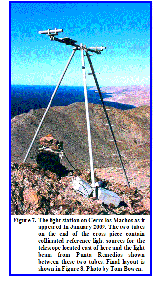
A requirement of the project was to minimize the light path over land. The light station on the island was thus located on top of a cliff on what is now referred to as Cerro los Machos at latitude 29° 17.645' N, longitude 113° 29.711' W, elevation 350 m (1,150 feet).
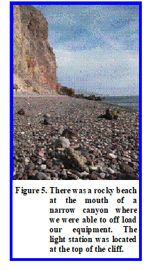
A narrow canyon led up to the light station from a very rocky landing area (Figure 5) where we could off load supplies from the LCVP.
Daytime temperatures commonly went to 50°C (120° F). In the narrow canyon where we worked across chocolate-brown rhyolites, temperatures were considerably higher than that. The rocks were commonly so hot that with Vibram-soled field boots we could not stop on the rocks. To rest we would have to find a sandy place and wiggle our boots down in the sand as one would barefoot on a beach. We would then sit on our packs unless, rarely, we could find a patch of shade. The rocks were so glassy and sharp that even Vibram soles would wear out in two weeks and the sides of our boots were cut as though by knives.
Nonetheless we would make two, and sometimes three trips a day up and down this canyon packing in the equipment, water, and food. Each trip involved a vertical gain of 350 m (1,150 feet) so each ascent was no small matter. Each of us required about 6 liters (>1.5 gallons) of water every day to simply survive in these conditions. And to cool off at the end of the day we would creep ever so slowly into the 30° C (85° F) Gulf water and take our canteens with us to chill them.
It also gets cold at night in the desert so sleeping gear had to be brought up as well when we slept on the peak. The C-rations I had purchased were supposed to be mixed meals but turned out to be ravioli and more ravioli, morning, noon, and night. Took me nearly 40 years before I could eat ravioli again.
As one objective was to minimize the light path over land, Cerro los Machos was ideal as the cliff on the water side was nearly vertical and we could hear the sea lions quite clearly on the beach 350 m (1,150 feet) below.
We were making good progress and got the frame of the light station erected and the wind generator up. I don't think we got the batteries packed in during this session. It was now near the end of August and Gary Drean (Animal) had to return to school so we sailed back to Bahia de los Angeles to resupply and put him on Baja Airlines and sent him back to San Diego via Tiajuana.
Following Drean's departure we received hurricane warnings.
On August 31, 1967, Hurricane Katrina made landfall on the southern tip of the Baja peninsula and traveled up it. Katrina did heavy damage, sinking 60 ships and leaving 2,500 homeless after it partially destroyed the city of San Felipe north of us. At Bahia de los Angeles Katrina dropped more than 25 cm (10 inches) of rain on this moonscape with widespread flooding outside the village. The name Katrina for a hurricane has taken on much larger disaster dimensions since our expedition but for the locals this one was bad enough.
We rescued a half dozen Mexican vessels during this hurricane using the R/V Charley Bear to tow them back to their anchorage.
The hurricane lasted a couple of days and it took a few more days to put things right around the village.
After the hurricane it was back out to the island. The light station survived Hurricane Katrina intact but the winds broke the wooden propeller on the wind charger. Nothing we could do about it until we got a replacement. We packed in the batteries and, after testing, turned the light off so as not to drain them.
But our weekly visit to the Charley Bear showed she now had a leak that we couldn't locate.
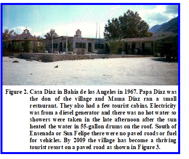
We then packed down the equipment we no longer needed, e.g., the Pionjar drill, and loaded it on the R/V Charley Bear across the rocky beach (Figure 5) and sailed back to Bahia de los Angeles and had a confab with Papa Diaz, the local don, about repairs. A couple of the local fisherman looked at the boat but couldn't find the leak either.
We then had to sail the R/V Charley Bear across the Sea of Cortez to Guaymas for repairs, the closest available boatyard. Guaymas is on the mainland on other side of the Sea of Cortez and southeast from Bahia de los Angeles, a distance of 153 nautical miles (283 km) as the crow flies and about 170 nautical miles (315 km) by sea. That made it a roughly one day trip at the 8-9 knot speed of an LCVP. As I was the only one who could steer a compass course most of the sailing devolved on me, especially at night.

Repairs to the R/V Charley Bear took about a week during which we devoured a great deal of Gulf shrimp. That was a welcome relief after a steady diet of turtle at Bahia de los Angeles and ravioli on Isla Angel de la Guarda. We even got to see a movie in an open-air theater.
We also took a bus up to Hermosillo to get some needed supplies and money. Credit cards came into vogue some time later and most all transactions had to be paid for with travelers cheques or cash.
Papa Diaz also needed some cement for a project back at Bahia de los Angeles. After the Charley Bear was repaired we loaded at least 40 bags of 40 kg (90 pounds) of concrete mix into the troop well and filled up our ten 55-gallon drums with diesel. LCVP's are designed to carry 36 combat-armed troops, or about 7,500 pounds (3,400 kg) of cargo. With 40 bags of concrete mix, ten 55-gallon drums of diesel fuel, and the three of us, the R/V Charley Bear was carrying about 8,500 pounds (3,850 kg) so we were definitely loaded to the Plimsoll Mark.
Around September 21-22 we set sail back to Bahia de los Angeles on what looked like a fair morning. But as soon as we rounded the southern tip of the headland forming Guaymas Bay and headed northwest we ran head on into severe weather. We then put into the bay on the west side of Guaymas and found shelter just offshore from a restaurant/nightclub called the Rio Rita. We anchored for the night and went ashore for dinner. The Rio Rita had an amazing entertainer who could make the tassels on her breasts go opposite directions or the same direction both ways, among other tricks, a welcome port in a storm indeed.
By morning the storm had apparently blown itself out and we put to sea again. However, by evening another storm brewed up and we were forced to alter course to the west. As we were low in the water, waves were continually breaking over the bow and starboard side. That presented no real danger as LCVP's have large bilge pumps. But we were forced to move the concrete bags aft in the troop well and cover it as best we could. It was one long, wet trip in an open boat. The only positive factor was the Gulf waters are very warm in September, about 30° C (85° F). But despite our best efforts to cover them, about half the sacks of concrete mix got wet and the concrete ruined, which certainly did not make us popular with Papa Diaz.
Sometime after midnight we came up to the Baja Peninsula and turned northwest again, hugging the coastline and what shelter we could find standing close in. That presented a hazard as we nearly ran aground on a reef in the early morning hours. Fortunately, breaking waves alerted us while still 50 or so meters off and we turned out to sea and went around.
By daylight the storm blew itself out and we sighted Isla Cabeza de Caballo marking the entrance to Bahia de los Angeles later that morning.
After resting up for a day and off loading the 55-gallon drums and concrete we made a reconnaissance cruise up the west side of Canal de Ballenas looking around Punta Remedios for landing sites and likely locations for a light source and reference, as well as access to a telescope site.
About September 24, 1967, we (myself, Lee Lopez, and “Guero”) ventured out, with our usual escort of a pod of orcas, to resume work on the island light station. We off loaded the R/V Charley Bear at the mouth of the canyon that gave us access up to the station on Cerro los Machos. Guero remained on the beach at the landing point while Lee and I sailed the Charley Bear down to Ensenada los Machos and anchored her by the stern about 50 m off the beach. We then started sailing the Sabot back to the landing point along the coast.
Unfortunately, a squall came up and the tiller broke while we were about halfway back. Without a rudder the dinghy quickly capsized. Lopez, and I made it safely to the beach on flotation cushions just after sunset, although I had some anxious moments before Lee made it ashore after I did.
We then walked along the beach under the stars back to the landing point beneath Cerro los Machos.
During the night a northwest wind blew and we could hear the waves breaking on the rocks a few meters below where we were camped on the rocky point. Estimated wind speeds were in the 25-30 knot range and the waves were no more than 1 to 2 meters (3 to 6 feet) where we were camped a few meters above the high tide level.
The next day the three of us began to pack the equipment we had landed the previous day from the beach up to the light station site, a vertical climb of about 350 meters (1,150 feet) as previously noted but which didn't become easier with repetition. On the second trip up the entire sole of my left boot came loose from the heel to forward of the arch. The only spare boots I had were back at Bahia de los Angeles. Given the conditions, there was no way I could continue working until I had adequate footwear. Thus, that afternoon we decided to hike back to Ensenada los Machos and return to Bahia de los Angeles on the R/V Charley Bear.
The bay was hidden from our view until we came up over a low ridge about 2 kilometers (just over a mile) from where the Charley Bear was anchored. As we crested the ridge it appeared that only the gunwales of the landing craft were above water. My first comment was that “I hope that is an optical illusion.”
Unfortunately, as we got closer it became clear that the R/V Charley Bear had sunk at anchor. I swam out to the boat and climbed aboard but clearly nothing could be done as the engine compartment and battery were flooded.
It was never clear why the boat sank. The waves from the previous night did not seem to have been high enough to have washed over the transom into the troop well. After the salvage, some minor dry rot was found in the stern and that may have opened up during the night. But we just had repairs made to the stern and thought all the rotten wood was replaced so the remainder cannot have been extensive? Perhaps the repairs had left a leak that went unnoticed?
Whatever the cause the three of us found ourselves shipwrecked and marooned on an unexplored desert island with only the water we had brought ashore. However, we did have plenty of ravioli to eat, although Guero repeatedly stated a strong preference for the Rio Rita.
After finding the R/V Charley Bear sunk we began walking back to our landing point along the beach. The dinghy had washed ashore and we pulled it up on to dry land above high tide. It seemed likely at the time that it might be necessary to improvise a tiller and sail the Sabot back across the Canal de Ballenas to Bahia de los Angeles if we were to escape.
After spending the night on the landing point where we had our camp it was decided to move our camp and available water up to the point where the light station was and attempt to radio for help. That took us all that day with me being of little help due to my damaged boot.
As soon as we moved up to Cerro los Machos I began broadcasting a Mayday morning, noon, and night on our Citizens Band walkie-talkie. After a couple of days, people in Missoula, Montana, picked up the skip and notified their sheriff department.
With some trepidation the Missoula County sheriff then put it on the teletype to the San Diego Coast Guard, who checked with Scripps as to whether they were missing anyone, which they promptly denied. However, after further checking, Scripps admitted, I understand with notable reluctance, that they knew about us. I heard from Prof. Vacquier later that they finally got around to calling him at about 0300 hours.
The Coast Guard then flew down the next day and found the R/V Charley Bear. While they circled around the boat at Ensenada los Machos I used an aluminized space blanket to signal them from Cerro los Machos 5 miles (8 km) away. They didn't have a Citizens Band radio but they flew over and dropped message canisters. After some arm signals from me in response to their messages, they left and arranged by radio for a boat from Bahia de los Angeles to come out and rescue us that afternoon.
We were marooned 2 1/2 days after finding the Charley Bear had sunk at anchor and had about another day of water left at the time of our rescue. We made it back to Bahia de los Angeles around September 28-29, 1967. Our rescue by the Coast Guard was, of course, widely broadcast by news media.
For reasons not understood, or explained to someone who still has the distinction of being the only Scripps' captain to have lost his vessel, they decided to salvage the R/V Charley Bear. As it was insured for the $5,000 it cost, one can quickly see that a vessel of such little value, sunk in a remote bay on an unexplored island was not a good candidate for cost-effective salvage. It should also be evident that I don't think like a bureaucrat.
At any rate, after making our way back to Bahia de los Angeles, and talking with the Associate Director and others via radiotelephone, it was decided Scripps would fly two experts down to help me salvage the boat. I tried to explain that I had a number of empty fuel drums, and that we could lash them to the boat at low tide. With a nearly 4 m (12 foot) tidal range, and the boat sunk at anchor in shallow water, the boat was known to be nearly on dry land at low tide. Thus, I was sure I could get the vessel afloat and back to the village if that was what they really, really wanted to do. Bureaucratic minds don't like to listen to the man on the spot, however. That is especially true when that idiot has just sunk his boat and made international headlines.
The “experts” from Scripps flew in to Bahia de los Angeles the following week via Baja Airlines and courtesy of Capitan Munoz, all around pilot, mechanic, and flight steward. Capitan Munoz only flew into Bahia de los Angeles a couple of times a week so there would have been some delay scheduling their flight down and Scripps getting them ready.
I had arranged to charter a boat from Papa Diaz in the village. The next morning, around October 6, 1967 (I am trying to reconstruct dates over 40 years later), we sailed out to Ensenada los Machos.
As the boat had been worked up the beach by the tides for nearly two weeks now, it was high and dry at low tide, as predicted. However, there was about 1 m (3 feet) of water in the troop well. Did I mention daytime temperatures in the 50°C (120°F) range? Anyway, these two “experts” surveyed the situation and then got down in the troop well of an 11 m (36 foot) landing craft and began bailing with buckets.
Since I was in disgrace, and not an “expert,” I didn't think I should interfere. Thus, I opined that while they bailed I would check the beach to see if anything of value had washed ashore. After a couple of hours beachcombing, with the tide starting to turn, I went back out to the boat where they were still bailing, though without much visible gain.
I made myself comfortable on the gunwale alongside the troop well on the opposite side from where they were bailing. I watched for a while, and it did seem like they were beginning to tire a bit. So while they were taking a breather, I mentioned that, though I wasn't an “expert,” all of the LCVPs I'd ever seen, including this one, had drain cocks in the bilge. I also pointed out that while the tide was out, the water inside the boat was higher than the level outside. So, while I didn't want to tell them their business, I thought if perhaps they reached down into the water about there on the port side, and at about the same place to starboard, they could feel the drain plugs. Unscrewing the drain plugs then allowed the water to drain out, as they had been designed to do. When the tide came in, it was relatively straightforward for them to replace the drain plugs without further help from me.
We then ran a line from the chartered boat to the R/V Charley Bear, and as the tide came in the boat floated, albeit leaking some. I did not feel then, or now, that these “experts” needed any further advice from me on how to bail in order to keep the boat afloat while being towed back to Bahia de los Angeles. So I returned to the chartered vessel where I oversaw the tow line during the voyage back while rehydrating. But engine noise prevented conversation with the “experts.”
A couple of days later, probably Monday or Tuesday, October 9-10, 1967, we flew back to Tiajuana via Baja Airlines. From Tiajuana Lee and Guero went back to Ensenada and the Universidad Autonoma de Baja California.
After some difficulty getting through U.S. Customs, which looked askance upon my by-then native visage and clothing, we made it back to Scripps about 7 PM, two hours later than planned. I must admit that the reception the Associate Director, Fred Spiess, gave me, after he waited those two extra hours, was not what a shipwrecked sailor might have desired.
On my arrival back in San Diego I found I had lost 23 kg (50 pounds) in body weight while in Mexico, a loss of over one-quarter of my weight the previous July.
It was decided that the best thing was for me to go off to a meeting at Lamont-Dougherty in Palisade, New York, for several days. Out of sight, out of trouble presumably. I spent less than a week in San Diego before flying back to the meeting at Lamont-Dougherty in New York.
Following that meeting I took a week vacation with a friend in Columbia, Missouri, on the way back. Fortunately for my morale, her welcome was much more to my liking than the one I had been given at Scripps. That week also allowed me to rehydrate, while still getting some needed relaxation and moderate exercise, and by the end of that week I had regained all of the 23 kg (50 pounds) I had lost, though I must admit it wasn't entirely water that I used to hydrate with.
I was probably back in San Diego by the end of October and sometime in November Vacquier and I flew down to Bahia de los Angeles, chartered Papa Diaz's boat and went out and inspected the light station we'd built. As noted above, the hurricane had broken the wooden propeller for the wind generator so we took a new one up and installed it. We also filled the batteries with water and Vic gave his approval to the location and station installation, particularly as the equipment had withstood the hurricane without damage other than the breakage of a wooden propeller on the wind generator.
Despite the fact that I could easily have replaced the R/V Charley Bear in San Diego for the $5,000 we paid for the first LCVP, Scripps, in the infinite wisdom and despite my protests, decided they would rebuild the original. As I was in disgrace for having lost the boat in the first place, I was naturally the last person they were going to listen to.
Scripps put a marine technician, Smitty, in charge of getting the R/V Charley Bear seaworthy again. He flew down to Bahia de los Angeles and chartered Papa Diaz's boat to tow the R/V Charley Bear back to Guaymas and got the boat repaired. I think he and someone else from Scripps sailed the Charley Bear back to Bahia de los Angeles and that is where it was when I returned to Scripps in late September 1968.
I also remember driving down to Ensenada in my Triumph TR3 with a girlfriend, coincidentally named Rita, to visit with Lee and Guero and recall our harrowing adventure with a few embellishments for Rita's sake. Guero was still expressing a desire to return to the Rio Rita. I saw Lee Lopez a couple of times after that at Scripps but I haven't ever run into Guero again. I hope he made it back to the Rio Rita. He was originally from Mazatlan on the mainland.
I had previously invented a method of measuring the heat flow in front of an advancing drill bit as part of the Deep Sea Drilling Project, which morphed into JOIDES, and is now the International Ocean Drilling Program .
As a result Dick Von Herzen offered me a temporary position at Woods Hole Oceanographic Institution (WHOI) to develop the method. Scripps gave me a leave-of-absence as, due to their idiotic decision to repair the Charley Bear, there was little for me to do for six months or so in San Diego. Besides, I wasn't exactly a favorite child at the moment, and with only a high school diploma I wasn't high in the academic hierarchy at this august institution where Nobel laureates were common.
I moved back to Woods Hole in late November-early December 1967 and worked there until September 1968.
While at WHOI on that cruise I came around a curve on the beach road one night in March 1968 on the way home and spun out in sand that had drifted across the road. Sports car fans may recall that Triumph TR3's had no seat belts or roll bars. But luck was with me and when the car rolled it came to rest upside down with the driver's compartment over a ditch.
I crawled out of the wreck and sat for a bit beside it contemplating the stars and the universe. Decided maybe the wild times should be reconsidered and age 30 was a good year to do that. Called up the on again/off again wife in San Diego and explained the situation. Since it was true love despite the classic battles of a him and her, she quit her job and flew out to Boston to meet me. We stayed together a total of nineteen years, including the horse trip described in the following adventure, graduate school, field work in the Solitario and much of the Mountain West, numerous moves, and two sons.
On our return to Scripps in late September 1968 I again ventured down to Bahia de los Angeles to check on whether the R/V Charley Bear was in all respects ready to put to sea again. To my chagrin, despite the expenditure of more than twice her original cost, there were still major, unresolved problems with the boat. Regardless, Vacquier, Smitty, Finn Outler (a retired Navy captain who was the Marine Physical Lab director), and I all flew down to Bahia de los Angeles and took the Charley Bear over to Isla Angel de la Guarda and got the International pickup back from where we'd left it inland from Ensenada los Machos.
I think Vic and I, and possibly Smitty, also hiked up to the light station on Cerro los Machos (Figure 7) and found all was well.
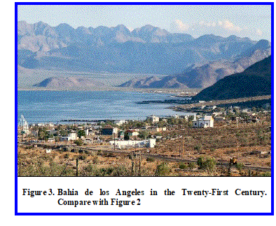
While Mexico has since greatly improved the roads in Baja California (see Figure 3 as compared to Figure 2), in 1968 the Baja 1000 was a notably rugged off-road race that only a few vehicles finished without major breakdowns. Bahia de los Angeles was about 200 miles (320 km) of dirt trail away from the nearest pavement that, on a good day, required 10 hours of hard driving to reach.
While Smitty and Outler flew back to Tiajuana, Vacquier and I drove the pickup back. In the past Vic had been somewhat critical of off-road driving skills that I had been developing since my youth and perfecting in Baja. However, on this trip Vic was driving and he ran over a large boulder that all but rolled us over. When the truck was upright again I commented that perhaps it was the road, or lack thereof, that was the problem, not my driving. Vic then had to agree and made no further comments about my driving skills.
After going back to school at UCSD in the fall of 1967, Gary Drean had been building a better field vehicle for the project. He converted two-and-a-half (the body of one) military surplus jeeps into one off-road vehicle with, at the time, new-fangled high-arch springs, a roll bar, canvas top, and oversized shocks. It may be of historical interest to note that the off-road equipment so common in 2009 was not then. To get these parts we had to go out to the house of the guy who started Border Parts in the evening, after he got off work from his day job. We also had to pay cash, which caused more problems with the University of California accounting system.
As may be evident, my operations often caused consternation for the bureaucracy at the University of California. MPL Director Finn Outler (Captain, USN-retired) once told me that he admired the way I got things done, that I never let obstacles stand in my way, but the debris in my wake...
But oceanographic operations are never simple and straightforward. So it should not be imagined that I was the only one who faced unusual difficulties, as will become clear as we proceed.
In late September 1968 my wife and I then took the refurbished jeep and drove back down to Bahia de los Angeles and went looking for suitable sites to put the light station and telescope on Punta Remedios on the Baja side. But we were having problems with the Charley Bear that should have been fixed when it was in the Guaymas shipyard. If one spends more than twice the original cost of a piece of equipment, and more than twice what it would have cost to replace it, I thought the problems should have been fixed. After a couple of weeks fighting the problems we had to go back to San Diego for parts.
Also, at this time a minor revolution, now known as the Tlatelolco Massacre, had broken out in Mexico City on October 2, 1968, and Federal troops had massacred an estimated 350 students in the square. Rumor had it that arms were being smuggled to the students via the Baja Peninsula, so that wherever we went the Federales were checking on us continually.
Prof. Vacquier pointed out that, given past problems, if there were further difficulties in Mexico that it would mean my job. Inasmuch as he had been strongly encouraging my return to school I thought his advice well worth following. I had reached the pinnacle in my position at Scripps some 2 years previously and the only way to advance was into an academic position for which I didn't have the degrees. In the circumstances I returned to Utah State University at the end of 1968 and continued on through my Ph.D. in geophysics at Texas A&M, finishing in 1976.
I think every organization has one. You've probably heard of armchair generals. In oceanography and the Navy they are known as freshwater admirals. Smitty was Scripps' Marine Physical Lab's candidate. Always ready to tell me how I should deal with the Mexicans, what I was doing wrong, how it should be done, etc. You know the type.
Since Smitty was an “expert” on dealing with the Mexicans and had been in charge of getting the R/V Charley Bear to sea again, when I left Vacquier put him in charge of the astrometric project.
Smitty then hired some Mexicans to help and rounded up some donkeys. I saw one picture with six or eight donkeys in the LCVP. With that help he began work on the second light station and finding a possible location for the telescope on Punta Remedios, which was never finished.
When the Mexican students and I were working out of Bahia de los Angeles, periodically a Mexican immigration official would visit in his twin Beech aircraft. We were always very friendly with him and he was curious about what we were doing, which we were happy to explain. Cordial relations all around although at one point he wanted to see the letters from the Scripps director asking for official assistance. I'm sure he had heard the tale of how we brought the R/V Charley Bear across the border at Mexicali and off loaded it at San Felipe. He didn't seem to miss much.
My experience with immigration and custom officials crossing numerous international boundaries by a variety of methods is that if you tell them up front and honestly what you are doing, what you are carrying (we often had weird instruments and equipment, e.g., an LCVP), and why, they were almost inevitably pleasant and relatively easy to deal with, although I often had to tell the same story to a number of officials.
It was a different story with Smitty. As noted, Smitty already knew it all and apparently didn't have a cordial relationship with the Mexican immigration official. Also, Smitty was hiring Mexican nationals and putting them at some risk without permits, insurance, etc. The risk factor was of some importance as I understand the Mexican press had reported Lee and Guero as dead when the R/V Charley Bear left us shipwrecked and marooned.
The story I got was that when Smitty was questioned about his operations he told the immigration official he could basically do what he wanted and that they didn't dare arrest him because of the international scandal it would cause. From all reports, and common sense, that wasn't the right thing to say and Smitty found himself in the immigration plane and taken to the Tiajuana jail.
I heard about it when a friend from Scripps, John Sclater, called me one evening in early March 1969 to tell me Smitty had been arrested and it cost Vacquier $800 to bail him out. I gather Vic had to personally go down to Tiajuana, pay the bail, and bring Smitty back.
This was a tragicomic incident as I understand Mexico ruled Smitty persona non grata as a result of this contretemps. Smitty had been planning to retire in Mexico after a few more years and I think he already had an interest in property there.
Obviously Victor Vacquier was not a man easily deterred or upset by minor issues like shipwrecks, revolutions, problems with immigration officials, or other such trivial issues that would long ago have stopped a lesser individual in their tracks.
Following the fiasco with Smitty and Mexican immigration the telescope and light stations were finished with the help of Prof. Jorge Valdes S., who I think was with the Escuela Superior de Ciencias Marinas at Ensenada, Baja California, and a detachment of Mexican Marines arranged for by Dr. Nicolas Grijalva of the Institute of Geophysics at the University of Mexico.
We had originally planned to put the telescope west of Punta Remedios on the Baja Peninsula but the terrain apparently dictated, or made it easier to put it inland from Cerro los Machos on Isla Angel de la Guarda and the final arrangement is shown in Figure 8. The light path has a bearing of N 85° E (roughly 25° from perpendicular to axis) across Canal de Ballenas and was capable of detecting as little as 4 mm transverse movement between the island and the peninsula
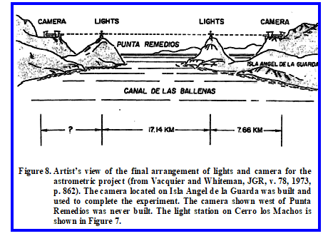
I have not visited the camera site, nor has the archeologist doing the review that prompted this rewrite, but the estimated location for the camera is at latitude 29° 17.73' N, longitude 113° 24.99' W on Isla Angel de la Guarda and Google shows three cleared areas near that location. Assuming the light station on Punta Remedios is at the same elevation as the one on Cerro los Machos, the camera elevation would be 350 m (1,150 feet).
Original plans also called for a second set of light stations and telescopes close to north- south across the Canal de Ballenas to detect spreading, as opposed to transverse motion between the island and the peninsula measured by the completed array. A light source on Isla Coronado (Figure 1, Isla Smith on Google) at the entrance to Bahia de los Angeles and a second one on Cerro los Machos would cross Canal de Ballenas at approximately a 45°þangle and presumably detect spreading of 6 mm or more. Such a set of stations would be perpendicular to the existing stations.
The way the project worked when it was finished was that a pair of lights on Punta Remedios (Figure 8) were lined up so that they shown through the pair of lights on the arm of the light station on Cerro los Machos (Figure 7) and were focused on a light-sensitive glass plate by a 10-m focal length telescope emplaced on the backbone of Isla Angel de la Guarda as shown in Figure 8. The glass plate was mounted behind a shutter that was operated by an automated timer during night hours. The glass plate was stepped upward for the next exposure by a screw mechanism.
What the camera registered then were a series of dots stacked one upon the other in a time progression as shown below:
° * * ° — Exposure One on photosensitive glass plate at time t1
° * * ° — Exposure Five at time t5
The outer dots ° are from the near light source on Cerro los Machos and the asterisks * represent the light source on Punta Remedios. Obviously if Punta Remedios moves relative to Cerro los Machos, the inner asterisks from the far lights would move on the photographic glass plates relative to the near lights when measured over time as illustrated.
Weather and atmospheric conditions were a big factor in whether or not a useful exposure could be obtained and the glass plates required replacement at least once a month, a considerable logistical problem for a camera located on the backbone of Isla Angel de la Guarda. Despite the automated system, most of the best exposures were obtained manually by Prof. Valdes, who camped out on the island to take them.
In the end useful exposures were obtained on ten nights over a period of two years on March 17, 20, 22, and 23 in 1970; December 15, 1971; and January 7 and 12, February 4, 5, and 6 in 1972. Despite a theoretical resolution of 4 mm of relative movement between the two light sources, no measurable transverse movement was detected across what is now known as a transform fault during these two years.
Bathymetry shows a deep trench in the Canal de Ballenas and the depth of this trench adjacent to continental sediment sources makes it certain that some of the movement of Isla Angel de la Guarda is away from the peninsula, i.e., the Canal de Ballenas is spreading as well as acting as a transform fault.
The light path is roughly 25° off a line perpendicular to the axis of the Canal de Ballenas so with a resolution of 4 mm approximately 45 mm, or 4.5 cm of spreading, versus transverse motion, should be resolvable. Apparently the Canal de Ballenas neither spread or slipped along its axis as much as 4.5 cm during the two years these observations were carried out.
The proposed light stations between Isla Coronado (Figure 1) and Cerro los Machos with a second telescope north of Cerro los Machos would have been capable of detecting spreading on the order of 6 mm by the astrometric method. The spreading rate is on the order of 4-6 cm per year on the East Pacific Rise, which the Canal de Ballenas is a northern extension of. So over a two year period one should see movement between the island and peninsula of 8-12 cm either as transverse motion or spreading, and likely over time a combination. The fact that no motion was detected does not detract from the visionary nature of the experiment.
Ortlieb et al. (1989) did a follow up study using laser trilateration methods with one station toward the south end of Isla Angel de la Guarda and stations on the Sierra los Animas and another atop Pico Alberto southeast of Bahia de los Angeles, and stations on Isla San Esteban and Isla Tiburon, among others. During the four years 1982-1986 they measured a right-lateral displacement of 17 ±4 cm, or just a bit over 4 cm per year across the Canal de Ballenas during this measurement interval.
Technology has now made it much easier to use differential Global Positioning System (GPS) stations. While GPS systems don't currently have the resolution of the astrometric method described here, displacements of 4 cm per year are easily resolvable with current GPS systems. A GPS system would also have the advantage that as few as two stations would be required to measure both transverse motion and spreading. Whether someone has undertaken that experiment in this locality is unknown to me. Certainly many groups are now making such GPS measurements elsewhere.
In October 2000 a party of three men on a fishing trip were also marooned on Isla Angel de la Guarda near Ensenada los Machos and one of them died during their trek on foot along the shoreline to Punta Refugio, where the two survivors were rescued. People Magazine interviewed me for that story, although I got no mention. That story later became an episode on the television series I Shouldn't Be Alive and their hardship illustrates the magnitude of what we faced thirty-three years earlier. Fortunately, our Citizens Band radio worked.
In 1978 the island was declared a federal refuge and in 2007 it became part of the Reserva de la Biosfera Bahia de los Angeles y Canal de Ballenas y Salsipuedes by presidential decree published on June 5, 2007. The process leading up to the declaration is detailed in the final chapter (PDF) of a book edited by Gustavo D. Danemann and Exequiel Ezcurra entitled Bahia de los Angeles: Linea Base 2007.
In 2004 the Mexican government began supporting a survey of places and events on Isla Angel de la Guarda and an Inventory of Cultural Resources of remains left by indigenous people is being conducted as of early 2009. I was first contacted about that project in February 2007. The survey includes the light station shown in Figure 7 that we built on what is now referred to as Cerro los Machos at latitude 29° 17.645' N, longitude 113° 29.711' W, elevation 350 m, in case you want to punch in the coordinates on your GPS and go visit the site. I doubt there is cell phone reception so I'd suggest you take a Citizens Band radio along at a minimum.
The Inventory of Cultural Resources on the island is being conducted by Thomas Bowen, and he inspired me to go back and update this adventure and provided additional background information used here. I must admit it makes me feel old to have an archeological survey being done of one of my early studies. On the other hand, what we knew as Humbug Bay where we moored the R/V Charley Bear and where it sank, now appears on current maps as Ensenada los Machos. I guess being regarded as macho men compensates. And macho man is something that certainly described Prof. Victor Vacquier before his death on January 11, 2009, in La Jolla, California, at the age of 101.
In July 2010 Betty Shor and my good friend John Sclater published an extensive biography of the incredible life of Victor Vacquier in EOS. With the permission of the American Geophysical Union that biography is available here (PDF). I highly recommend their article to anyone interested in the history of science and how the concept of seafloor spreading and plate tectonics evolved. Looking back on just the heat flow program led by Vacquier, the scale of what we did is amazing. Papers in 1966-1967 on heat flow Northwestern Pacific, heat flow Hawaiian area, heat flow Eastern Pacific cover a big chunk of the planet!
| Home Page | Contents | Index | Comments? |
| Next — Horseback through Utah, Arizona, and Colorado |
| Back — Defeat on Popocatépetl |