| Home Page | Contents | Index | Comments? |
| Next — Education and Career |
| Back — Shipwrecked and marooned |
On to the Kaibab Plateau and the Grand Canyon
Into the desert and through Monument Valley
On to Four Corners and Colorado
West Elk Wilderness and on to Aspen
A minor revolution, now known as the Tlatelolco Massacre, occurred in Mexico City on October 2, 1968. Federal troops massacred an estimated 350 students in the square. Rumor had it that arms were being smuggled to the students via the Baja Peninsula, where I was working at the time for Scripps Institution of Oceanography. That stirred up the Federales like a hornet's nest and they were checking on us continually.
Prof. Vacquier pointed out that, given past problems, if there were further difficulties in Mexico that it would mean my job. By past problems, he was discreetly referring to a shipwreck, and the accompanying loss of face. Inasmuch as he had been strongly encouraging me to return to school, I thought his advice well worth following. I had reached the pinnacle in my position at Scripps some 2 years previously and the only way to advance was into an academic position, for which I didn't have the degrees.
As a result, I resigned my position at Scripps and returned to school at Utah State University in Logan, Utah, in January, 1969, where I had started some 10 years before after my discharge from the Marine Corps. Utah State was then on the quarter system and I completed a Bachelor of Science degree in geology in four quarters, graduating in March, 1970.
Prof. Vacquier had strongly recommended me to his friend, Dr. Kenneth Cook, at the University of Utah. After completing my bachelors degree I planned on continuing for a Master of Science degree in geophysics there. But graduate school didn't start until late September of 1970. As graduation from Utah State approached, and I had been accepted to graduate school at the University of Utah, I suggested to my wife, Ruth, that we go on a five-month horseback trip during the break. She immediately agreed.
After leaving Scripps we had sold our house in Del Mar, California, at a modest profit. The money from that was sufficient to cover our needs while on the trail and buy the horses and equipment.
It might help to explain that my wife had been a sky diver, stock car racer, demolition derby driver, and TV comedian before she made the mistake of marrying me. So a horse trip sounded like a wonderful adventure to her.
It wasn't until after we started buying the horses that I found out Ruth was afraid of them. At first she would stand on one side of the fence and pet her horse's nose if he didn't do anything too fast. But she was determined to go and a minor thing like fear hardly slowed her down at all. So she bravely learned to ride and handle the horses like a trooper.
My Dad showed me how to shoe a horse and helped us pick out two saddle horses and a pack animal while I was finishing up my bachelors degree.
Unfortunately, Ruth's father was dying of lung cancer at this time, so at the end of March she went back to Iowa to visit him for a couple of weeks. During that period I arranged to have the horses trucked south to the old Corry homestead northwest of Cedar City, Utah. It was still very much winter in Logan and we wanted a more southern climate to begin such a trip so early in the year.
After getting the horses to Cedar City I put some final touches on the supplies and equipment with some help and guidance from my uncle, who was also the local brand inspector. When Ruth got back from Iowa we started out on April 5, 1970, up Cedar Canyon along Coal Creek.
On the first day we made about 15 miles and stopped at the Iron County campground. Fifteen miles was to prove an average day's distance during the trip. On our longest days we made about 25 miles, and a few days we covered 10 miles or less. On one day while trying to reach the North Rim of the Grand Canyon through deep snow we only covered 3 miles. Also, the horses could only be ridden for three to five days, and then had to be rested for a day or two.
The trip almost ended that first night when we went for a walk to stretch our legs and came back to find the tent fly on fire. Fortunately, the damage was limited to the fly, and we learned to be very careful with the campfire.
Like most any physical exertion, you think you are going to die the first week. The second week there is a chance you'll live, and after two weeks you have been doing it all your life. So it was with the horse trip. The first day we could hardly walk at the end of the day. During the first week all the hair on the inside of my thighs curled up and pulled out. Ruth had saddle sores on her thighs that eventually developed into calluses. But after the first couple of weeks we thought nothing of six to eight hours in the saddle. We would get off and walk occasionally, mainly to rest the horses.
The next day, April 6th, we continued up Cedar Canyon and over Cedar Breaks to Duck Creek along Highway 14. The reader should understand that modern roads commonly follow the only practical trails in the west. At this time of year only the road was open through the snow on Cedar Breaks. So for the first few days, and commonly throughout the trip, we would have to ride beside a road. Water is the other limitation in the West and, again, current roads connect watering places.
However, after Duck Creek, on the third day we rode down through Long Valley Junction, off the beaten path, and on to Paunsaugunt Plateau. We bore generally southeast. After several days of getting “cliffed up,” and having to retrace our route to find a way down and around, we came out into the headwaters of Johnson Canyon, of western movie fame.
We took a couple of days to ride down that scenic canyon and decided to go into Kanab to rest and resupply. We put the horses up at the local fairground and, for the only one of two times on the entire trip, stayed in a motel for two nights. Later, my parents would come through Kanab looking for us and be told that a man and his boy had ridden through. For ease of maintenance, Ruth was wearing her hair very short, and she is very petite.
After leaving Kanab we rode south along Highway 11 to Fredonia, crossing over into Arizona. The local sheriff told us about a water hole just south of town and we set up camp for the night. However, the land owner showed up, and he was one of only three people we met on the entire trip who was very disagreeable. He finally relented and allowed us to camp there for the night as it was near dark and our camp was established with the horses hobbled and off grazing.
From Fredonia we rode south along a logging road and up on to the Kaibab Plateau heading for the North Rim of the Grand Canyon. Given the early time of the year, as we got closer to the rim, and higher and higher, snow became more of a problem.
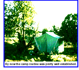
By now the camp routine was pretty well established. Usually around 4 or 5 PM we would look for a camp site, hopefully with water. As we got further into the desert we might stop earlier if the map did not show any other windmills or springs within 5 miles or so. After unsaddling the horses, and leading them away from camp, they would be hobbled and the pack horse belled.
Note that it is important to lead the horses away from camp immediately after they are unsaddled as the first thing they do is piss. Horse piss near the camp site obscures the scent of sage and pine one is probably in the wilderness to enjoy after a day on the trail.
While I was hobbling the horses, Ruth would begin setting up the tent. Because of the duration of our trip, we had an 8'x10' wall tent that added considerably to the pack horse's burden but made our lives immeasurably more comfortable. When I got back to camp, I helped finish setting up the tent, and she would then start spreading out the sleeping bags and pads while I started the camp fire. After some time to sort ourselves out and do any camp chores, equipment repairs, or horse shoeing if one of the animals had lost a shoe that day, I would cook dinner while she prepared KoolAid and other side dishes. After eating Ruth would help clean up and we were usually in our sleeping bags as soon as the sun set.
In the morning, I would cook breakfast and help clean up and pack the cook gear while she began breaking camp. While I went off to find the horses, which sometimes took awhile, Ruth would put the sleeping bags in the stuff sacks and begin taking down the tent. After getting back with the horses I would help her fold and put the tent in its bag. I would then saddle the horses while she stored our gear in the alfogas (pack bags). Depending on circumstances, we were normally on the trail between 9 and 10 AM on travel days.
Because of the limited stamina of the horses, every fourth or fifth day had to be a rest day. On those days we would make and mend any gear needing it, or shoe one or more of the horses if needed. Horse shoeing and fighting forest fires are at the bottom of my list of preferred occupations.
The horses also got into a routine and expected their grain every morning. On one rest day on the Kaibab we were sleeping in. About 7 AM we were awoken, however, by the pack horse, Bill, standing and looking in the front of the tent and shaking his head to ring his bell. The other two horses were standing on either side of the tent looking in the side windows. I was obliged to get up and give them their grain.
We generally carried food for ourselves to get us by for at least a couple of weeks, though sometimes towns were a little closer than that. We also bought about 100 pounds of grain for the animals when the opportunity offered. The endurance of the horses suffered markedly when we ran out of grain, as we did as we struggled with the deepening snow and steep canyons approaching the Grand Canyon.
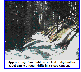
About a week out of Fredonia we were approaching Point Sublime when we encountered drifts in a steep canyon that we could find no way around. Because of the cold and poor forage the horses had also grown very weak. We tried to break a trail on foot through the drifts and lead the horses through. But the pack horse bucked his way over the side of the hill while trying to break his way through the snow after about 100 yards. He ended up upside down about 15 feet down the slope in the timber. At this point we were about 3 or 4 days from help of any kind at about 8,600 feet around the first of May. So the situation wasn't ideal.
Ruth was trying to help the pack horse but ended up on the downhill side of him. He was kicking for all he was worth and I thought she was going to end up with something broken. I finally got her to move away from the animal and managed to cut the ropes holding the alfogas on, thus freeing him of the packs. By pulling his head downhill we managed to get him on his feet and then back up to the trail while somehow managing to avoid getting kicked or stepped on, or any broken bones in horse, man, or woman.
It was obvious we were not going to get the horses through the drifts on the trail so we led the horses back down to an open park and hobbled them. I had to carry the alfogas up from where I had cut them loose and back to the park. We ate lunch and considered the situation.
After further reconnaissance it looked as though we could cut a trail through the snow drifts for about a mile and then wait for the snow to freeze that night. By starting very early in the morning we thought we could get the horses through the drifts before the snow softened up again the next day.
We spent the remainder of the day cutting a 3- to 4-foot deep trail wide enough for the horses for about a mile through the canyon that blocked our progress. I would cut out blocks of snow with the camp axe and then Ruth or I, sometimes both, would toss the blocks over the side. We also tramped the trail down as best we could as we worked.
Needless to say, we were ready to hit the sack that night. We left the horses tethered near camp so that they wouldn't hobble off. Our sleeping bags proved their worth that night as it was so cold that the trees were cracking.
We got up about 3 AM. Our levis had gotten wet cutting trail so our first problem was to crack the ice and get into them. Then our boots were so frozen that we had to put our feet in them a little way and wait for the boots to thaw some, then push a little further until finally we could get a foot all the way in. Then repeat the process with the second boot.
We had a hasty, cold breakfast mainly of jerky while we were breaking camp. My saddle horse had wound himself up in the tether and would probably have frozen to death in another couple of hours. I imagine he found the saddle blankets a comfort that morning.
By about 4:30 AM we had the horses saddled, camp broken, and started leading the horses along the trail we had cut the previous day. Given the cold night, the trail was firmly frozen and we had no difficulty leading the animals along as they now had firm footing. After getting past the drifted canyon we only went far enough that day to find a good campsite with some forage for the animals. As we were now along the rim of the canyon above The Dragon near Point Sublime, we did a bit of sightseeing on foot that afternoon after pitching camp.
The next day we had more level ground along the rim but again ran into snowdrifts that we couldn't find a way around in a canyon we had to cross. Having learned our lesson, we did a reconnaissance on foot and found that the drifted area was only about 100 yards across. Out with the camp axe and started digging trail while leaving the horses tethered. A couple of hours digging and we had a trail we could lead the horses through. By then the day was pretty well gone and we pitched camp in a likely spot early in the afternoon.
We and the horses were at a pretty low ebb. Bill, usually our pack horse, was a high-wethered gelding and developed very bad pressure sores on his wethers.We had also run out of grain for them. Bill was easily able to carry the alfogas most of the time but after we had run out of grain on the Kaibab Plateau we had found it necessary to switch packs to my saddle horse for a day. That didn't work well either and we walked most of the time.
However, the next day brought us to the lodge on the North Rim and the wranglers at the horse corrals were incredibly nice to us. It was still early May and the park wasn't yet open to the public. They put our horses up in their corral with all the hay and grain they could eat, and us in their bunkhouse. One of the wranglers also showed us how to doctor Bill's wethers and cut out the saddle pads to relieve the pressure on them. All at no charge!
Our original plan had been to cross the Grand Canyon by trail from the North Rim to the South Rim but we found out that the Park Service was working on the water line to the South Rim and the trail was closed past Big Spring in the canyon. However, it worked out that a crew had been working at Big Spring for some time and the wrangler was leading an empty string of mules down to get them. Since mules do tend to need a little guidance, he offered to take us down if we would each lead a string of mules. So in addition to free board and room we also got a guided tour down the trail to Big Springs on mules while our horses rested. Needless to say, this was a very welcome break for all of us.
 All good things come to an end, and after four days of rest and recuperation, with plenty of grain, the horses seemed ready to hit the trail again. Since we couldn't cross the canyon, we started north along Highway 67. A few miles after crossing the north boundary of the park my parents found us. They were driving south on the highway looking for us. They bore the sad news that Ruth's father had died, which she had been expecting. Nonetheless she was very grief stricken at the news and we stayed in a motel that night with my parents after finding a corral that would put up the horses.
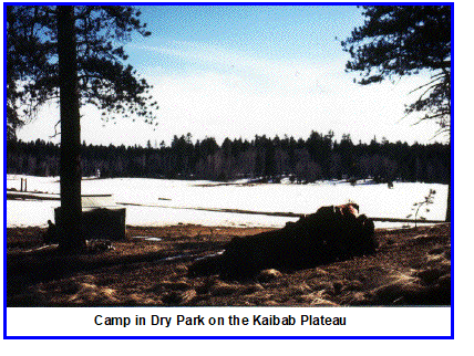
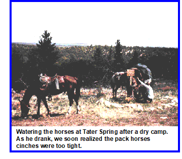
After spending the morning with my parents, we started down the eastern flank of the Kaibab Plateau over Cocks Combs ridge. We were looking for Tater Spring for the night's campsite. However, with our small scale map (1:250,000) we were unable to find it after about an hour's search. So we made a dry camp in the juniper and cedar overlooking House Rock Valley.
The next morning we resumed our search for the spring and found it downhill within a few-hundred yards of where we had camped. We paused to water the horses. After watering them the pack horse started going crazy and trying to roll the alfogas off. After a bit it dawned on us that we had cinched him up on an empty stomach and he had just drunk over 5 gallons of water. We quickly took the packs off and loosened his, and the other two horses, cinches. With their cinches loose, they all decided to have a bit more to drink, after which we cinched them tight and continued down off the Kaibab Plateau into House Rock Valley.
Water is scarce on the Colorado Plateau and we had been told by a couple of Arizona game wardens we had met on the Kaibab that there was water at the House Rock Buffalo Ranch. That reserve is maintained by Arizona Fish and Game and the wardens assured us that we would be welcome there. So when we hit the valley floor we turned south for several miles to water and spend a night. However, our reception was extremely cold and rude, and it was a great burden on this misplaced bureaucrat to even allow us to water our horses. Camping there was definitely out. I emphasize this individual's boorish behavior because it was so atypical of Western hospitality. He was the second of three obnoxious individuals we met on the trip.
For those unfamiliar with southern Utah and northern Arizona, any travel is constrained by where you can cross the canyons. That is particularly true with the Canyons of the Colorado. Not having been able to cross the bridge at Phantom Ranch in the Grand Canyon, the next possible crossing to the east was at Marble Canyon near Lee's Ferry, which the Mormon pioneers had originally established as the only crossing of the Colorado for more than a hundred miles in either direction. To the west, the next crossing is at Hoover Dam near Boulder and Las Vegas, Nevada.
This area was the last to be explored in the United States during the westward expansion by European settlers and is still traversed only with great difficulty off the beaten path. As we were only making about 15 miles a day, any detours were one to two weeks in duration.
After being grudgingly allowed to water our horses at the buffalo ranch, we started riding back north toward highway US 89 in order to cross the bridge at Marble Canyon. We recovered the miles wasted going south and continued on about 10 more miles where we found water at the House Rock ranch. Made for one of our longest day's rides at about 25 miles.
The rancher, Frank Mackelprang, then age 72, was a son of pioneers, and knew of my Dad and my Uncle Rulon who was a brand inspector. As spring roundup had finished a couple of weeks earlier the bunkhouse was empty. When we stopped to ask for water and a place to camp, he put us up in the bunkhouse for three days.
The rest was necessary as coming down off the Kaibab had been hard on the pack horse's wethers.
On our first night there we sat on the front porch of the ranch house with Mackelprang and watched the full moon come up over Shinumo Altar and House Rock Valley. Moonrise in the desert are always magic but that one is unforgettable.
Ruth remembers getting to cook on an old-fashioned wood-burning stove in the sod-roofed bunkhouse and the resulting dirt on the bunks. Field mice had found a home there as well. But to us it held all the comforts of home.
On the fourth morning, as we were packing to leave, Mackelprang fixed breakfast for us and growled “You don't have to leave, I ain't sicced the dogs on you yet!” But we didn't want to overstay our welcome and wanted to get across Monument Valley before full summer if possible.
That day was another long one to make it to the next water at Marble Canyon. But Mackelprang's breakfast and hospitality are still remembered.
Navajo Bridge over Marble Canyon of the Colorado marked our entrance on to the Navajo Reservation. We stopped for the night before that near the village on the west side of the bridge and watered the horses out of a borrowed wheelbarrow. We met a number of characters there, including a Los Angeles policeman with any number of stories to tell. So we swapped sea stories till long past our normal bedtime.
To get over the Echo Cliffs on the east side of Marble Canyon by car it is necessary to drive about 12 miles south to Bitter Springs and then back north about 15 miles to Page, Arizona. However, we wanted to go to Page to resupply, which is only about 10 miles from Navajo Bridge as the crow flies. Via Bitter Springs it would have taken us nearly a week but we met a Navajo who told us of a trail over the cliffs. After some scouting the next morning to find the trailhead, we managed to get the horses up over the cliffs although Bill, the pack horse, slipped on the rocks and took a chunk out of his lip.
We only made about 7 miles that day but that took us to a windmill near highway US 89 about 5 miles out of Page. An easy ride of about 5 miles took us into town the next day.
At Page we met some folks who arranged for us to camp at the local fair and rodeo grounds and put up the horses there. Had to buy hay and grain for the horses but it was well worth it. We rested for a couple of days and toured Glen Canyon Dam while there.
We also met the Navajo brand inspector, and he knew my uncle Rulon as well. He updated our paperwork for Arizona brands, and the morning we left he drove our packs south along our route for about 20 miles to the next water near Kaibito. So we were able to cover the distance mostly at a canter and make an easy day of it for the pack horse. For background, it is possible to run a loaded pack horse, but it isn't advisable, and sure messes up the packs. Hard on the animal as well. So it was a rare day when we got the horses above a walk, particularly with the sores on Bill's wethers.
That night Ruth's saddle horse slipped out of his hobbles and went yondering. My horse and the pack horse felt obliged to follow even though they still had their hobbles on. In the soft sand we were unable to track them and Bill had a habit of standing still if he saw us so his bell wouldn't ring, unless of course he wanted his grain. Since they were well rested and grained after Page they thought wandering was fun. After trying in vain for a couple of hours to track them we walked to some hogans and found a Navajo woman who got her husband to track them down for us. That cost us a day's travel.
The desert heat dried up the leather hobbles and caused them to chafe the pastern on the horses legs. When we tried them a bit looser they slipped off. We also tried to tighten them up and keep them on the cannon, or shank, above the fetlock with occasional success. We also applied Bag Balm extensively but in the sand that may have made things worse.
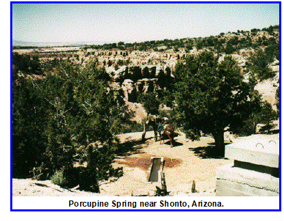
The next day we made it to Porcupine Spring near Standing Rock west of Shonto.
We had talked about going to Rainbow Bridge from here but the sores on Bill's wethers were not getting any better. At this camp we met some friendly Navajos who offered to sell us a jenny mule to help carry our packs. The only catch was the mule wasn't broken and had run free all four years of her life. It also took them a couple of days to round her up.
The Navajo there also showed us how to make hobbles out of cotton rope that were much easier on the horses legs.
At this point some background is needed. First, my people, the Mormons, have always got along with the Indians they settled among. So we were asked a number of times if we were Mormon or “White.” They generally don't like “whites,” particularly as associated with the Bureau of Indian Affairs, and in the trading posts. After some time with them, assuring them of my Mormon heritage, and that my people were from Cedar City, we were welcomed.
To further embellish the tale, for years I had been telling Ruth that if she didn't want me, there was a beautiful redhead named Cynthia who would gladly have me. So when our Navajo friends finally rounded up the jenny mule, and she turned out to be red, we both looked at her and instantly named her Cynthia.
We had no experience breaking wild mules so the Navajos told us how to do it by tieing her up next to one of our horses and starving her down for a week. While tied up, we frequently waved blankets around her face, threw them on her back, and curried and handled her as much as possible.
We needed another pack saddle and alfogas for the mule. Our friends took us into Shonto in their car or pickup several times while I called home and to get supplies. Mom and Dad were living in Roy, Utah, at the time. Dad found us the pack saddle and bags in Ogden and put them in the mail to us care of General Delivery in Shonto. We also had to buy hay for my saddle horse, Joe, that we had to keep tied up with the mule.
All this took about two weeks. During that time there was a rodeo and games at Inscription House north of where we camped by Porcupine Spring. Our friends hauled us up there for that and we had a great time.
After starving Cynthia for about a week and saddling and unsaddling her numerous times, she needed to be trained to lead with the saddle and alfogas on. So we saddled up and took her out. Things went well for awhile but something spooked her and she took off. I was able to hold her for a bit but to keep the lead rope from tripping my saddle horse I had to let her go. Ruth and I tried to catch her but she was on her home ground and disappeared after bucking the alfogas off. Back to our friends with a tale of woe. They willingly saddled up and went out, tracked her down, and brought her back to us.
With the two week delay to break Cynthia it was now approaching mid-June and we needed to be across Monument Valley and into the mountains before the full heat of summer. The route to Rainbow Bridge would have added weeks to our journey and we decided to go straight through Monument Valley in order to get into the mountains in Colorado by July.
When traveling like this, days and weeks are a bit disjointed. While I had a watch, time was generally determined by the position of the sun in the sky. As a result, dates given here are generally only approximate.
After getting Cynthia back we spent a few more days training her and leading her out a few more times with a lariat around her neck if she tried to make a break for it.
In mid-June we broke our camp at Porcupine Spring near Standing Rock and rode on through Shonto and out to US Highway 160 toward Kayenta. At a camp near Marsh Pass the Navajo told us of a spring a couple of miles northwest of Kayenta. We stopped there for a couple of days as both Ruth and Bill, the pack horse, got colds.
We used some diluted horse liniment on Ruth and some of our first aid supplies on Bill.
As we left Kayenta and headed north along US Highway 163 through Monument Valley, both Ruth and Bill still had bad coughs. Ruth found by experimentation that Bill would eat her cough drops and they actually seemed to help. Since Cynthia was still only half broke I was leading her alone and Ruth was leading Bill.
The horses were very weak from their colds and lack of forage. About 10 miles north of Kayenta, Cynthia got the lead rope worked up under my saddle horse's tail. That always caused him to buck. This time he went down like he was going to buck but he was so tired he simply lay down. I then stepped out of the saddle and got the rope out. We then walked for a ways to let him rest up.
Water is scarce in Monument Valley and we were pretty much tied to within a couple of miles of following the highway through it.
With the horses sick and tired it was a short day and we stopped at a windmill around El Capitan Wash. The windmill had an overhead spigot for filling water tanks on trucks. We took advantage of that to take showers after dark although a truckload of Navajos drove up shortly after Ruth got all wet. She had to scramble for cover but getting clean was mighty welcome.
The next day put us back into Utah, climbing up and over Monument Pass. We camped on the north side of the pass. That was a dry camp but sure a pretty sunset. The horses and mule spread out for forage and stood out against the setting sun. Fortunately for the animals, this was our last dry camp.
After the camp near Monument Pass, we rode down into Mexican Hat, Utah, the next day. Up until this point the mule had gone unshod. I wasn't quite up to shoeing a half-broke mule until she got a little tuckered out. Also there hadn't been a whole lot of something sturdy to tie her to while I was shoeing her. I've had to throw horses to shoe them but didn't want to try it with Cynthia the first time. In the sand she had no problem but as we got up abreast of Alhambra Rock she was limping pretty badly in the shale and sandstone. Took it slow the last couple of miles and found a beach on the north side of the bridge across the San Juan River at Mexican Hat.
As there was no putting off shoeing her anymore, we found a nice sturdy sign post at the entrance to the bridge the next day, and tied her up to that. I put a jerk rope through her halter and Ruth held that tight so when Cynthia started to kick it pulled her head down. Being as how she was tired and sore, I managed to shoe her all the way around with only a minor struggle.
There was forage along the San Juan River and the horses picked up a little. After the day off we rode east to Comb Ridge. Climbing up over a rocky trail on the ridge my saddle horse decided to stop when he got to the top and take a breather. However, the other animals were stuck on a narrow, rocky trail below him where they were scrambling for footing. Took considerable persuasion to get Joe moving before the other horses and mule lost their footing. After that we decided that spurs were a necessity.
We found a nice campground that night along the San Juan in some cottonwoods. Cynthia was getting feisty about being hobbled, however. That night as I bent down to put her hobbles on she tried her damndest to take a bite out of me. I was tired, and hot, and mad. I stood up and took as big a bite as I could out of her neck. Came away with a mouthful of mule hair but she never tried to bite me again.
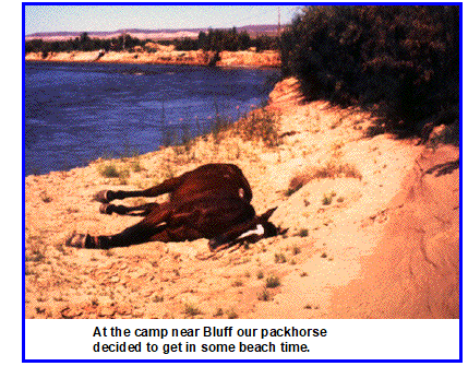
An easy ride brought us into Bluff. We stopped to eat first at a cafe and met an asinine judge who complained that our horses might leave road apples in his pristine village. Fortunately the locals made him see some sense and we met a very nice young lady who volunteered to drive us up to Blanding to get some supplies the next day. We then found a nice camp spot down on the river bank among the salt cedar and the horses took a break.
The horses generally had to be shod about once a month and they would wear out their shoes in a month to two when we weren't in sandy terrain. As the shoes got thinner there was a tendency for them to pull them off in the rocks. Once a shoe was lost it had to be replaced that evening, or sooner in very rocky terrain, or the animal would go lame. Horseshoes and grain are very heavy items to carry so we could only take limited amounts with us. It was always a problem for us to find grain and horseshoes in the smaller villages like Bluff, so her help was very welcome.
We also bought some spurs as the incident on Comb Ridge wasn't forgotten. Took us a bit to figure out how to wear them, though. But after that we never rode without spurs. Makes for a lot safer riding in the mountains with those devices on.
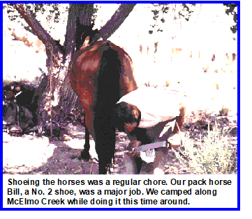
We rode generally east for a couple of days along the San Juan after leaving Bluff. We turned northeast at Aneth along McElmo Creek. Forage was a problem still but we now had water regularly. Took a day off to shoe the pack horse, Bill, and one of the other horses near the trading post.
At Ismay Trading Post, on the Colorado border, we turned off from McElmo Creek and followed Yellow Jacket Canyon up to its head during several days riding. Forage became less of a problem as we ascended Yellow Jacket. These were uneventful days when we didn't see another soul.
One day in what must have been early July we came up out of Yellow Jacket Canyon roughly 10 miles due west of the village of Arriola. All of a sudden water was a problem again. The pinto bean farmers in the area truck in their potable water as there is no surface water. As was so often the case, one of the farmers couldn't have been more helpful. He not only gave us water for our horses but drove us into Cortez for supplies that evening as well.
Without readily available water we did not linger, and the next day we continued riding eastward, crossing US Highway 666 at Arriola. Found a field and water that night and continued to the Dolores River the next day. Arrived in the town of Dolores on a weekday and rode by a Forest Service ranger station that was open. From them we obtained a number of forest trail maps that would be invaluable in the months ahead.
It proved to be a long days ride but we made it to a camp at the confluence of the east and west forks of the Dolores River about 1 mile west of Stoner, Colorado. Near our campsite was an abandoned field of alfalfa. As this was an ideal site, we laid over to rest the animals and let them eat their fill.
My saddle horse, Joe, ate so much that after three days he looked as if he were pregnant. All of the animals quickly put on weight. The only exercise they had was a short trip into Stoner to do laundry and get some supplies.
After this camp, the animals never lacked for forage and water, and we seldom dropped much below 10,000 feet before the end of the trip. By now the horse- and deer-flies, together with four-engine mosquitoes, were out in force. The animals were bitten to the point where blood was running down their flanks. We would rub them down with repellent each night but they would sweat it off during the day. Bugs rarely bothered Ruth or I, apparently due to the wood smoke that clung to us, and other smells. We would get bitten for a bit after the rare occasions when we had a shower, or bath in a creek, and were clean. But a night around a campfire and we were left alone again.For she and I biting insects were almost never a problem, in stark contrast with the horses.
From this camp we rode up on to Stoner Mesa and northeast into the heart of the San Juan Mountains along an old stock trail. It was a steep climb up on to the mesa but we had a reliable indicator of how hard the horses were pressed. Joe would pass gas from all the alfalfa every second step. When he ran out of gas we knew it was time to stop and give them a break.
It was fairly easy going along the crest of Stoner Mesa and we reached Calico Peak on the second day. We were now at elevations of 11,000 to 12,000 feet but the summer was well advanced and we had no trouble with snow. The first time we camped above 12,000 feet Ruth got elevation sickness while dressed in her rain suit. She had a few anxious moments getting out of it before she was sick. A good nights sleep and she was fine.
The days and the nights were idyllic and we rarely saw anyone for days on end.
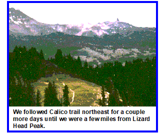
We followed Calico trail northeast for a couple more days until we were a few miles from Lizard Head Peak. We then turned down off the ridge into Snow Spur Creek and State Highway 145 just west of Lizard Head Pass.
Coming down off the ridge we lost the trail and I continued on ahead leading the mule. Ruth stopped to pay nature a call and lost sight of me. She was leading Bill, who was very trail-wise about what he could get through with the packs on. So when Ruth tried to take him through some close-growing quaking aspen, he balked. She got mad at him and forced him, at which point he got stuck, and couldn't go forward or back. As I thought they were behind me all along, I didn't miss them for some time. After I realized I had lost them I tied off Cynthia and started back up looking for them. Finally found them and cut one of the trees down to get Bill out. We then rode together down to where Cynthia was and on off the ridge to the highway where we made camp.
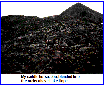
The next day we followed the highway for a few miles and then turned southeast at Trout Lake up a trail to Lake Hope, where we camped for the night.
Joe never had learned to handle his hobbles with the little baby steps the other horses used. Instead he would rear up to advance his front legs together. He could run pretty good in the hobbles though. At Lake Hope we were well above timberline and in steep rocky terrain. Joe's lack of ability with the hobbles led him astray in the rocks and he got himself trapped. His Appaloosa coloring also blended in very well with the rocks in this area so we didn't notice his predicament till nearly dark. I then had to climb the mountain above camp, take his hobbles off, and lead him back down to more level ground near the lake with the other animals.
We continued up over a pass in the morning and descended down South Fork Creek into Silverton, camping for a couple of days on a bench near the confluence with Bear Creek just west of town. Then, as now, Silverton is a rip-roaring tourist trap, but it did offer an opportunity for both Ruth and I to get hair cuts, do laundry, take hot showers, and lay in some groceries. We went back some years later after the boys were born and rode the narrow-gauge train up from Durango. Silverton hadn't changed.
From Silverton we started north up the Animas River through all the old mining camps. We spent the first night near Eureka and then continued up the river toward Engineer Mountain. Just over the pass around Engineer Mountain, near an abandoned house of some repute, we happened on a sheepherder's camp. He had just killed a sheep and had an excess of fresh mutton. It was also drizzling, and looking like it would get serious about raining. Therefore, we accepted his invitation to stop and pitch camp near his wagon. As the rain kept up, we stayed for three days, and he sure seemed to enjoy the company. We enjoyed the mutton but my saddle horse, Joe, sure gave his mare a bad time. Finally Cynthia got jealous and bit Joe a good one and things seemed to settle down.
When we left on the fourth morning, the sheepherder stood out and waved until we disappeared over the ridge. A lonesome job he had and was glad of the company. You sure appreciate folks a lot more when they are few and far between.
Continuing north brought us into the Uncompahgres. We rode just below Wildhorse Peak on the tundra, as we were now well above timberline. We rode east across a divide and around the southern side of Wetterhorn and Matterhorn Peaks. Our trail then took us up across the western shoulder of Uncompahgre Peak before starting down into the valley of the Cimarron River where we camped that night just below timberline.
A couple of easy days followed as we rode north down the Cimarron River to a village of the same name on the south side of the Black Canyon of the Gunnison. By now Cynthia was trail broke and we simply tied her lead rope on to Bill's packs and I led both pack animals. That left Ruth free to just enjoy the scenery, and the back end of the pack string in case something happened with the packs or animals.
We had friends in Ouray and a phone call brought them up to see us. Some horse doctoring was necessary and our friends loaned us a car for a couple of days so that we could get some grocery shopping and laundry done, and visit the vet.
The horses and mule had gotten ear ticks. All of them except Bill would let us spray their ears to get rid of these ticks. Bill went wild when we tried to do him. I chopped down a small, 4 to 6 inch diameter, cottonwood tree to make a hitching post for the treatment. Even with the lariat choking him, Bill uprooted the stump when we tried to spray his ears. I think we finally got enough in his ears on a rag to discourage the ticks but it was a battle royal.
The pressure sores on Bill's wethers had never completely healed so we got a couple of more saddle pads to raise the pack higher. As the wrangler had shown us at the North Rim, we notched out the pads around his wethers. The vet also gave us some better medicine than what we had been able to find along the trail. With Cynthia now carrying half his load, and these improvements, his sores got better after we left Cimarron.
The Black Canyon of the Gunnison forms a barrier to traveling north from Cimarron. We had to ride east along US Highway 50 to the dam that forms Blue Mesa Reservoir in order to head up into the West Elk Mountains.
After crossing the dam we rode north up Soap Creek. We had been riding for months and rarely saw people until we got into the “wilderness” area. Now we encountered tens of people out for their wilderness experience . I've lived and worked for most of my life in the western United States and about the only time I've seen people out in the wilds in any numbers are in places the government has designated wilderness or park. Seems kind of strange that with all the wild lands we have out here that a person would need to be told it was “wilderness” before they went hiking or camping there. I guess that sheep mentality saves the rest of it for us though.
Having people around was a little embarrassing for Ruth the second day traveling up Soap Creek. She had to pay her respects to nature and stepped off the trail about 20 feet. While she was squatted down about 20-30 people from Outward Bound trooped by. All she could do was smile and wave.
During July and August in these mountains an afternoon thunderstorm happens nearly every day and we encountered our fair share for the rest of the trip. Mostly they were a minor inconvenience that mostly served to wash any insect repellent off the horses that they hadn't sweated off.
We continued up to the headwaters of Soap Creek in a couple of days and then skirted around Storm Ridge and over Beckwith Pass. Coming down the east side of the pass Bill found that he could put his big (he wore #2 shoes) front feet together and kind of ski down the muddy trail. He was doing pretty good there and would repeat his little trick on every down grade that gave him an opportunity. After about an hour of that there was a rock in the middle of the trail where he was sliding down. The rock forced his front feet apart and in the mud those front feet just kept getting further and further apart. With his packs pushing him down the slope, his eyes got bigger and bigger as his feet got further and further apart. Finally, he managed a big buck and got his front legs under control again. After that he decided skiing wasn't as much fun and didn't do it any more.
After Beckwith Pass the trail took us down into Anthracite Creek, then east over Kebler Pass, and down into the old mining town of Crested Butte.
Though I didn't know it then, we would later spend five summers in Crested Butte (or more colloquially, Crusted Butt) while I worked for a mining company. I was also to write a book about laccoliths, of which the West Elk Mountains are prominent examples. In 1970, Crested Butte was still somewhat of a mining town and the ski area hadn't gotten off to a good start. Still the tourists and trust-fund babies were in evidence. We weren't impressed then, or later, though we bought some tomatoes that Ruth carefully stashed atop Bill's pack saddle so they wouldn't get smashed.
We kept riding, bearing north past Mount Crested Butte (another laccolith) and up to the East River where we found a campsite on what we thought was national forest land. About two hours after setting up camp, eating the tomatoes, and settling in for the evening, some damnyankees came along and said we were on their five acres and we would have to move immediately. No fences, no boundary markers, no signs, no nothing but inhospitable people. Never have liked Yankees! Fortunately, these damnyankees were the third, and last, of the meanspirited people we met on the trip.
Nothing for it but to round up the horses and mule, break camp, and move up the road while it was getting dark. Finally, around 9 PM we found a spot, threw off the packs and saddles, hobbled the horses again, spread out our bags, and went to sleep. Guess our not putting the tent up made the horses nervous because, after grazing for a bit, Joe came over a laid down about five feet from our heads. The other horses stayed within about 50 feet of us the whole night as well.
Breaking camp the next morning was easy, The horses were right there so no need to hunt them down.
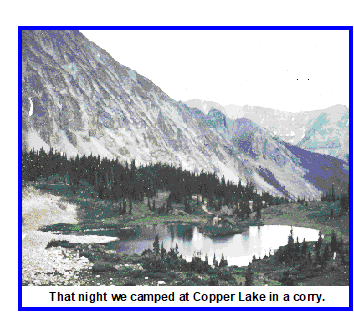
We continued up the East River for a few miles and then turned up Copper Creek at Gothic. That night we camped at Copper Lake in a corry, and a lovely spot it is.
The next day took us up and over East Maroon Pass and down past the Maroon Bells. We found a campsite in a meadow along Maroon Creek a couple of miles west of Aspen.
Cynthia's shoes needed to be redone, and one of the other horses. In the morning we rode in to Aspen and bought some supplies and did the laundry. Put some money in the parking meter for the horses while doing our chores. The tourists loved the horses and our mule.
We had lunch in a restaurant and then back out to camp.
Shoed the horse first, as they were well used to it. Then turned all the horses loose, as they were well camp-broke by now, and didn't wander far. Tied the mule up close to a stout quaking aspen. Hooked up the jerk rope with Ruth holding it and got her front feet reshod without major mishap. Then went to do her right rear foot. As I was trying to pull the old shoe off, a time when you are most vulnerable to being kicked, the horses decided to go for a run right by where I was shoeing Cynthia. Of course that set her to kicking and bucking, jerk rope or no. Guess I'm glad my DI used to punch us in the solar plexus to toughen us up while I was in Marine Corps boot camp, because she got me with both steel-shod hooves right in my rib cage. Laid me out for a bit and thought I was broken up. It was all I could do to climb the hill up to the road, and after Ruth closed up the tent against the inevitable afternoon rainstorm, we hitchhiked into the Aspen hospital. The kick caused my muscles to spasm, and I was in considerable pain, but nothing was broken. A shot for the pain eased the muscle spasms and an Ace bandage around my chest and I was good to go. Decided to have something to eat before heading back to camp while I rested a little. Then we found a ride out to camp with a former English professor who was then running a riding stable just outside Aspen.
Next day the mule still needed shoeing, so after resting up some in the morning, we tied the horses up out-of-sight of Cynthia. Hooked up the jerk rope good and got the job done. Rested up some more after that but was back to what passes for normal the following day.
After my recovery we rode east through Aspen and up Hunter Creek into the Hunter-Fryingpan Wilderness Area. For some days we rode north along or near the crest of the Sawatch Range. We saw no one except each other and the horses.
These are spectacular mountains but my only memories are of infinite horizons in all directions. We stayed high but no landmark stands out in my mind after nearly 30 years. The animals didn't give us trouble, water and forage were abundant, and supplies acquired in Aspen carried us well. Even the afternoon thunderstorms don't seem to have bothered us much during this period of summer in the Colorado high country. I do remember one afternoon riding through a small collection of cabins in a cloudburst with no one in sight. But our rain gear held and the packs were covered. After a few months at it we were trail wise to most of nature's ways.
The next landmark I recall is looking down from a high divide, probably Tellurium Park, and seeing a forest fire burning northwest of Woods Lake. As there is a resort there we went down and past the lake, camping for a night nearby, but didn't resupply as it was only a tourist trap boutique.
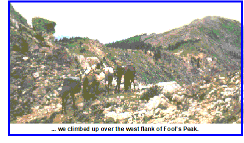 From Woods Lake we climbed up over the west flank of Fool's Peak. Stopped to look at a stamp mill for an old mine most of the way up the mountain. Hard to imagine how those big chunks of iron got there as the trail we were on was the only evidence of any way in or out. They sure hadn't gotten wagons in there.
After cresting the ridge above the old mine workings we rode down into Brush Creek and Yeoman Park. We camped that night near Fulford Cave and met some very nice people who were chicken farmers from Nebraska.
Actually we didn't have much option about meeting these people. They were eating at a picnic table, and the horses and mule hobbled over and stood like sentinels, one on each side of their table, watching them. When we noticed what the animals were doing we went over to rescue the people and, hence, got to know them.
It was time for a layover day so we spent the next day relaxing. The people from Nebraska were going back home the day after this and very kindly gave us all their extra food. Enough of everything else to keep us going another week, especially plenty of eggs.
Ruth had started the trip afraid of horses but when her horse, Poco Veli, lay down for a nap in a meadow here she used him for a pillow and took a nap herself.
The camera we had broke at our Fulford Cave stop so we have no pictures of the rest of the trip.
From Fulford Cave we went east, climbing up and over New York Mountain. We then headed north down Lake Creek and crossed the I-70 freeway at Edwards. Restocked a bit at a small store there, then continued north up Berry Creek.
At camp that night it was time for a bath as this was the lowest we had been in nearly a month. The water is mighty cold in the mountains when you are above 10,000 feet, even in the summer. The creek was muddy but I think we added some silt to it and got the better of the exchange.
Going for weeks without a bath on the trip wasn't something we particularly noticed. We did notice our hair getting sticky and greasy though. So even before this, when we were high in the mountains, we would wash each others hair by pouring a pan of water over the other's head. The water was so cold it would give us a headache. We would have to wait for a few minutes till we could stand the next pan full. Sure felt good to get our hair clean though.
It was now the first part of August, though we would have to run a date check when in town, or when we met someone, as we hardly kept up with time to the nearest week.
From our camp north of Edwards we continued generally north along the west side of the Gore Range for a couple of days.
We came down the Piney River to Highway 131 and rode a few miles to State Bridge to cross the Colorado River. We found a camp site in the flood plain on the northwest side of the river. It was time for a rest day and we hitchhiked a couple of miles up the highway to a small village. Managed to get our laundry done and stock up on groceries for the first time in several weeks, thanks to our friends from Fulford Cave.
From State Bridge we continued generally north along the west flank of the Gore Range. We crossed Highway 134 near Gore Pass.
North of Gore Pass the range is flat on top and we knew it as the Park Range. It is difficult for me to imagine more idyllic conditions than riding in high summer though broad, flat parks separated by stands of conifers and quaking aspen. Springs and creeks provided plenty of water and forage for the animals was abundant. The elevation was between 9,000 and 10,000 feet with warm days and cool nights. Though it was August, I don't recall a single thunderstorm that came anywhere near us during this period, and we seldom saw other people.
Though we didn't hurry through the Park Range, we did make our way slowly north, crossing US Highway 40 a few miles west of Rabbit Ears Pass. Made camp that night by a small lake.
We continued riding north, crossing the Continental Divide, and up past the east side of Rabbit Ears Peak.
We rode along the east side of the Continental Divide for a couple of days but time finally caught up with us. From someone we found out it was the 31st of August, The next day we turned southwest and crossed over the Continental Divide again at Buffalo Pass and made our final camp near Fish Creek Falls a few miles east of Steamboat Springs, Colorado.
By the time we turned southwest to Steamboat Springs we were less than 25 miles from the Wyoming border and had ridden virtually the entire length of Colorado.
We tried for a couple of days to sell the horses and mule in Steamboat Springs in order to avoid having to transport them back to Utah. We couldn't find a buyer at what we thought might be a reasonable price.
Ruth then took a Greyhound bus back to Ogden, Utah, where my parents met her. She got a horse trailer and started pulling it with our old Volvo. However, even empty, the horse trailer was too much for the Volvo. As a result, she left the trailer in Dinosaur on the Utah-Colorado border and drove back to Steamboat Springs to get me.
My Dad had an old Chevrolet pickup that we thought could do the job. After some phone discussion with him, we drove straight back to Roy, outside of Ogden, Utah, where my parents lived. Since we couldn't leave the horses run wild for very long, after getting Dad's pickup, we drove straight back to Dinosaur.
After getting the horse trailer it was on to Steamboat once again. Think we drove for about 24 hours. Since Ruth had already driven from Roy to Steamboat trying to pull the trailer, she had been going for about 36 hours.
After a quick check on the horses when we got back to camp, it was into the sleeping bags for about 12 hours. That was about September 6th.
The next day we loaded the horses into the trailer and made a more leisurely drive back to Roy, Utah. Dad had arranged for some pasture so that wasn't an immediate problem. However, once back in civilization I got terribly sick at my parent's house. I talked to Ralph on the porcelain telephone for several days from both ends. I was too sick to even go to bed and would lay on the couch near the bathroom. During the horse trip I had never been sick but apparently it took me a while to get used to civilized food. Wouldn't want to blame my Mother's cooking.
I started graduate school at the University of Utah on September 22, 1970. In the interim, Ruth and I bought an old house off Fourth South near the university and began fixing that up.
We sold my saddle horse and the mule at auction that fall in Ogden. We kept the pack horse, Bill, and Ruth's saddle horse until early 1977 and used them extensively while doing my dissertation research.
| Home Page | Contents | Index | Comments? |
| Next — Education and Career |
| Back — Shipwrecked and marooned |