| Home Page | Contents | Index | Comments? |
| Back — Becoming a geophysicist |
I did so well with the terrestrial heat flow program at Scripps Institution of Oceanography that during 1966 Prof. Victor Vacquier gave me a project he had attempting to measure continental drift between the Baja Peninsula and the mainland using the same astrometric methods astronomers have for measuring the proper motion of stars.
Basically, to measure the proper motions of stars you use two fixed points of light for reference, i.e., stars that are effectively infinitely far away, and a third point that is moving, e.g., a nearby star, photograph them over time with a telescope and, if you know distances (usually measured by red shift for stars), you can easily calculate how far the third point moves.
Note that at the time continental drift was a rather radical concept proposed by Alfred Wegener in 1912 and virtually ignored afterward. The concept of seafloor spreading was brand new, having been proposed by Harry Hess in 1960, and only a few radicals, like Vic Vacquier's group at Scripps had accepted it. Vic had been given the stuffed albatross award in 1963 for displacing the Pacific Ocean by 1,120 km (700 miles) along the Mendocino Fracture Zone after completion of the PIoneer survey by Mason and Raff using Vic's magnetometers. So the idea that the Baja California Peninsula was floating away from North America was not mainstream science. But minor details and obstacles never slowed Vacquier down.
As originally proposed the idea was to set up a light station on Isla Tiburon and a telescope at Bahia de las Angeles. Never content to keep my mouth shut, after being given the project I told Vacquier the experiment needed to be redesigned, and moved so the light path was across the Canal de Ballenas between Isla Angel de la Guarda and the Baja Peninsula. Based on the available bathymetry I argued the main fracture zone, or spreading center, must lay beneath the Canal de Ballenas, and the light path would be considerably shortened. Remarkably, he agreed with me. As Vacquier put it in a salary review dated June 30, 1967, that I came across while reviewing my work in 2009 at the request of an archeologist hired by the Mexican government:
“...Corry reviewed the geological information with the help of Bob Fisher and convinced me that a much nearer island, namely Angel de la Guarda was just as good. This overcame morass of logistic and political difficulties and increased the precision of the measurement by a factor of four at least...”
Shortening the light path is not to say the logistics were all that simplified. At the time, the Sailing Directions stated that Isla Angel de la Guarda was unexplored. The nearest village, Bahia de los Angeles, on the Baja Peninsula, was 20 to 30 nautical miles away by sea across the Canal de Ballenas.
To overcome the issue of transport we got a surplus LCVP, of the type used to land troops and light vehicles across beaches, and named it the R/V Charley Bear. The concept was good but the boat sank at anchor in what is now known as Ensenada los Machos in late September 1967 and left myself and two Mexican students shipwrecked and marooned on Isla Angel de la Guarda as we were finishing the first light station on what is now referred to as Cerro los Machos latitude 29° 17.645' N, longitude 113° 29.711' W, elevation 350 m (1,150 feet). And that occurred just a few weeks after we had weathered the worst hurricane in 25 years and days after we returned from Guaymas where we had the R/V Charley Bear repaired.
Scripps, rather unwisely in my opinion, decided to salvage and rebuild the R/V Charley Bear. During the year that took I was given a leave of absence when Dick Von Herzen offered me a temporary position at Woods Hole Oceanographic Institution (WHOI) to develop the method I had previously invented of measuring the heat flow in front of an advancing drill bit as part of the Deep Sea Drilling Project, which morphed into JOIDES, and is now the International Ocean Drilling Program .
I returned to Scripps in late September 1968 and started work on the astrometric project again. However, a minor revolution, now known as the Tlatelolco Massacre, broke out in Mexico City on October 2, 1968. Federal troops massacred an estimated 350 students in the square. Rumor had it that arms were being smuggled to the students via the Baja Peninsula, so that wherever we went the Federales were checking on us continually.
Prof. Vacquier pointed out that, given past problems, if there were further difficulties in Mexico that it would mean my job. Inasmuch as he had been strongly encouraging my return to school I thought his advice well worth following.
The astrometric project was then taken over by one of the technicians from the Marine Physical Laboratory at Scripps. He hired some locals to help and was transporting donkeys in the LCVP that were being used as pack animals. However, there was a problem with Mexican immigration officials and in March 1969 he ended up in the Tiajuana jail, from which Vacquier had to bail him out.
Victor Vacquier was not a man easily deterred or upset by minor issues like shipwrecks, revolutions, problems with immigration officials, or other such trivial issues that would long ago have stopped a lesser individual in their tracks.
Following the fiasco with Mexican immigration the telescope and light stations were finished with the help of Prof. Jorge Valdes S., who I think was with the Escuela Superior de Ciencias Marinas at Ensenada, Baja California, and a detachment of Mexican Marines arranged for by Dr. Nicolas Grijalva of the Institute of Geophysics at the University of Mexico.
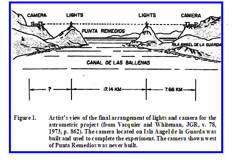
We had originally planned to put the telescope west of Punta Remedios on the Baja Peninsula but the terrain apparently dictated, or made it easier to put it inland from Cerro los Machos on Isla Angel de la Guarda. The light path has a bearing of N 85° E (roughly 25° from perpendicular to axis) across Canal de Ballenas and was capable of detecting as little as 4 mm transverse movement between the island and the peninsula.
I have not visited the camera site but the estimated location is at latitude 29° 17.73' N, longitude 113° 24.99' W on Isla Angel de la Guarda. Assuming the light station on Punta Remedios is at the same elevation as the one on Cerro los Machos, the camera elevation would be 350 m (1,150 feet).
Original plans also called for a second set of light stations and telescopes close to north- south across the Canal de Ballenas to detect spreading, as opposed to transverse motion between the island and the peninsula measured by the completed array. A light source on Isla Coronado (Isla Smith on Google) at the entrance to Bahia de los Angeles and a second one on Cerro los Machos would cross Canal de Ballenas at approximately a 45°þangle and presumably detect spreading of 6 mm or more. Such a set of stations would be perpendicular to the existing stations. But the difficulties and expenses of the project made this impossible at the time.
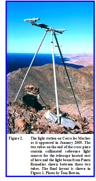
The way the project worked when it was finished was that a pair of lights on Punta Remedios (Figure 1) were lined up so that they shown through the pair of lights on the arm of the light station on Cerro los Machos (Figure 2) and were focused on a light-sensitive glass plate by a 10-m focal length telescope emplaced on the backbone of Isla Angel de la Guarda as shown in Figure 1. The glass plate was mounted behind a shutter that was operated by an automated timer during night hours. The glass plate was stepped upward for the next exposure by a screw mechanism.
What the camera registered then were a series of dots stacked one upon the other in a time progression as shown below:
° * * ° — Exposure One on photosensitive glass plate at time t1
° * * ° — Exposure Five at time t5
The outer dots are from the near light source on Cerro los Machos and the asterisks represent the light source on Punta Remedios. Obviously if Punta Remedios moves relative to Cerro los Machos, the inner asterisks from the far lights would move as illustrated on the photographic glass plates relative to the near lights when measured over time.
Weather and atmospheric conditions were a big factor in whether or not a useful exposure could be obtained and the glass plates required replacement at least once a month, a considerable logistical problem for a camera located on the backbone of Isla Angel de la Guarda. Despite the automated system, most of the best exposures were obtained manually by Prof. Valdes, who camped out on the island to take them.
In the end useful exposures were obtained on ten nights over a period of two years on March 17, 20, 22, and 23 in 1970; December 15, 1971; and January 7 and 12, February 4, 5, and 6 in 1972. Despite a theoretical resolution of 4 mm of relative movement between the two light sources, no measurable transverse movement was detected across what is now known as a transform fault during these two years.
Bathymetry shows a deep trench in the Canal de Ballenas and the depth of this trench adjacent to continental sediment sources makes it certain that some of the movement of Isla Angel de la Guarda is away from the peninsula, i.e., the Canal de Ballenas is spreading as well as acting as a transform fault.
The light path is roughly 25° off a line perpendicular to the axis of the Canal de Ballenas so with a resolution of 4 mm approximately 45 mm, or 4.5 cm of spreading, versus transverse motion, should be resolvable. Apparently the Canal de Ballenas neither spread or slipped along its axis as much as 4.5 cm during the two years these observations were carried out.
The proposed light stations between Isla Coronado and Cerro los Machos with a second telescope north of Cerro los Machos would have been capable of detecting spreading on the order of 6 mm by the astrometric method. The spreading rate is on the order of 4-6 cm per year on the East Pacific Rise, which the Canal de Ballenas is a northern extension of. So over a two year period one should see movement between the island and peninsula of 8-12 cm either as transverse motion or spreading, and likely over time a combination. The fact that no motion was detected does not detract from the visionary nature of the experiment.
The results were published by Victor Vacquier and R. E. Whiteman as Measurement of fault displacement by optical parallax in vol. 78, no. 5, of the Journal of Geophysical Research on February 10, 1973 (pp. 858-865).
Ortlieb et al. (1989) did a follow up study using laser trilateration methods with one station toward the south end of Isla Angel de la Guarda and stations on the Sierra los Animas and another atop Pico Alberto southeast of Bahia de los Angeles, and stations on Isla San Esteban and Isla Tiburon, among others. During the four years 1982-1986 they measured a right-lateral displacement of 17 ±4 cm, or just a bit over 4 cm per year across the Canal de Ballenas during this measurement interval.
Technology has now made it much easier to use differential Global Positioning System (GPS) stations. While GPS systems don't currently have the resolution of the astrometric method described here, displacements of 4 cm per year are easily resolvable with current GPS systems. A GPS system would also have the advantage that as few as two stations would be required to measure both transverse motion and spreading. Whether someone has undertaken that experiment in this locality is unknown to me. Certainly many groups are now making such GPS measurements elsewhere.
| Home Page | Contents | Index | Comments? |
| Back - Becoming a geophysicist |